The Chalk
The Chalk as an aquifer
The Chalk is the major aquifer of southern and eastern England. It is a microporous white limestone with low matrix permeability. It is an aquifer due to its well developed interconnected network of fractures. Yields (typically of the order of 150 l/sec) are highest where the density of fractures is greatest and/or where the fractures are enlarged (sub-karst) typically in the top 80 to 100 metres of the aquifer.
Porewater found at depth in the aquifer may be saline, particularly where the Chalk is confined by Palaeogene and Quaternary deposits in the Thames Basin and across East Anglia. The Chalk is prone to diffuse pollution from nitrate and pesticides associated with agricultural activity at the land surface and more locally by point source pollution, for example from leakage or spillage of industrial chemicals and petroleum hydrocarbons.
BGS has published a number of regional memoirs on the Chalk aquifer, as well as an on-line memoir for the Thames Basin that includes information on the Chalk in this area.
See also the Chalk in the BGS lexicon of named rock units.
Area where the Chalk is present
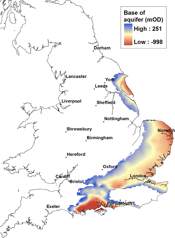
The Chalk is present in the south east of Yorkshire, southwards across the Humber and into Lincolnshire. It is also present east and south of the Wash in a swathe across central southern England from north Norfolk, through the Thames Basin and along the Kent coast, down to the south coast, the Isle of Wight and into Dorset towards Portland Bill. It is associated with the iconic scenery of the Chalk downlands and the white cliffs in and around Dover.
Elevation of base of the Chalk

The Chalk is exposed at the land surface along its western margins and generally dips east and southward. The base of the Chalk unit to the north of the Humber and along the east coast East Anglia is typically at a depth of the order of 500 m below OD, while in the centre of the Wessex Basin near Southampton the base of the Chalk may be in excess of 700 m below OD.
Contact
Please contact BGS Enquiries for more information.


