Aquifers and shales
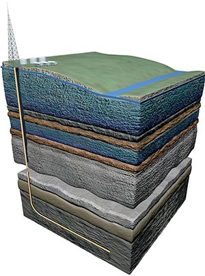
If shale gas resources are to be developed in the UK, the implications for groundwater will need to be considered as part of any risk assessment. This assessment can help us to understand and quantify the spatial relationships between the potential shale gas source rocks (including both shales and some clay units) and overlying aquifers.
The BGS aims to provide an overview, at the national scale, of the spatial relationships between principal aquifers and some of the major shale and clay units in England and Wales. This is done through a series of national scale aquifer/shale separation maps and supporting information about the geology and hydrogeology of the rock units.
Maps
A series of occurrence maps shows the distribution of rock units that form the principal aquifers and some major shale and clay units in England and Wales. In addition, a series of separation maps show the vertical separation between pairs of shales or clays and overlying aquifers.
Background information
Groundwater is an important source of water for public supply, industry and agriculture, and it also sustains flow in our rivers and environmentally important wetlands. Find out more about groundwater and how it is protected, as well as where shale gas forms (in both shales and some clays), how shale gas is produced and what impacts this may have on groundwater.

Contact
Please contact BGS Enquiries for more information.

Aquifers and shales
3D groundwater vulnerability
Methane baseline
Environmental monitoring
See also
Partner
Contact


