
Stoke St Michael and Oakhill
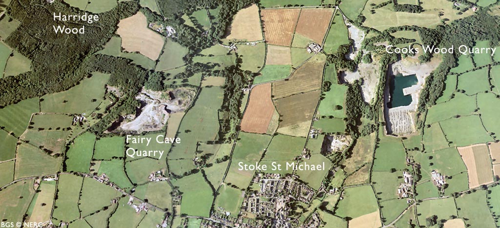 Aerial view of Stoke St Michael (click to enlarge view).
Situated on the northern flank of the Beacon Hill Pericline, Stoke St Michael and Oakhill lie on the narrow plateau of steeply dipping Carboniferous rocks sandwiched between the higher ground formed by Devonian and Silurian rocks to the south and the younger Coal Measures exposed in the Nettlebridge valley. The limestone outcrop is pockmarked by several disused quarries and hosts several quite extensive cave systems.
Quarrying
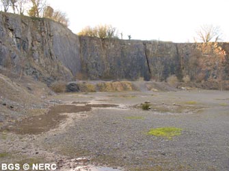
Much of the Carboniferous Limestone sequence has been exposed by quarrying. The Vallis Limestone is exposed in the privately owned Stoke Lane Quarry near Stoke St Michael. Further down the valley is the dormant Cooks Wood Quarry, which offers an outstanding section through the upper part of the Carboniferous Clifton Down Limestone and the overlying Oxwich Head Limestone. The limestone here dips at about 80° to the north. The Oxwich Head Limestone consists of a series of sandy limestones with thin beds of soft mudstone and some coal that form prominent recesses in the cliff face. The coal developed during temporary periods of low sea level during the Carboniferous.
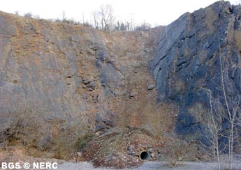
The Clifton Down and Oxwich Head Limestone is exposed in the disused Fairy Cave Quarry, through which runs the Withybrook Fault.
The upper part of the Oxwich Head Limestone also outcrops in Whitehole Quarry. A prominent bedding plane at the rear of the quarry is covered in hollows which have been interpreted as Carboniferous 'tree boles', developed at a time of low sea level when trees grew on the emergent limestone surface. These hollows were formed by rain water flowing down the tree trunk and dissolving the limestone around its base.
Caves and springs
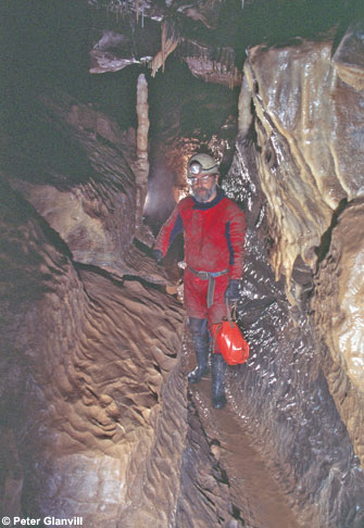
The area contains several cave systems formed where streams draining the sandstone slopes of Beacon Hill sink underground on reaching the Carboniferous Limestone. Some of these stream sinks can be followed underground. The largest of these is Stoke Lane Slocker. Here the stream can be followed by cavers for almost 2 km towards the resurgence at St Dunstan's Well in the Nettlebridge valley. This spring is the major resurgence for most of the stream sinks (or 'slockers') in the area, and has a mean flow of about 150 litres per second. Nearby, Fairy Cave Quarry has intersected a network of caves feeding this spring. Approximately 4.5 km of cave passage has been explored, of which about 0.8 km has been removed by quarrying.
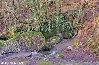
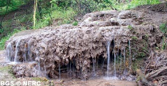
Several other springs rise from the Carboniferous Limestone. Three small springs, partially fed by stream sinks around Oakhill emerge in Ashwick Grove, while to the east, Whitehole Spring in Leigh Wood is a good example of a tufaceous spring.
The water here is saturated with calcium carbonate which is precipitated as tufa, a very porous, pale grey rock which forms a series of stepped dams known as gours.
Flora
The contrasting rock types form a variety of different habitats in the area including an area of species-rich unimproved limestone meadow limestone near Stoke St Michael.
The Quartzitic Sandstone outcrop gives rise to acidic, nutrient-poor soils giving rise to an association of plant species rare on Mendip.
- Home
- Overview maps
- Locality
areas
- Cheddar Gorge
- Charterhouse
- Blackdown
- Burrington Combe
- Shipham & Rowberrow
- Crook Peak & Axbridge
- Banwell to Churchill
- Priddy
- Harptree & Smitham Hill
- Draycott & Westbury-sub-Mendip
- Wookey Hole & Ebbor Gorge
- Wells
- Great Elm & Vallis Vale
- Mells & the Wadbury Valley
- The Vobster area
- The Whatley area
- Torr Works & Asham Wood
- Beacon Hill
- Stoke St Michael & Oakhill
- Holwell & Nunney
- Shepton Mallet & Maesbury
- Gurney Slade & Emborough
- The Nettlebridge valley
- Geology
- Minerals and mines
- Quarrying
- Caves and karst
- Biodiversity
- Detailed site information
- Acknowledgements
- External links
- Search
- Site map