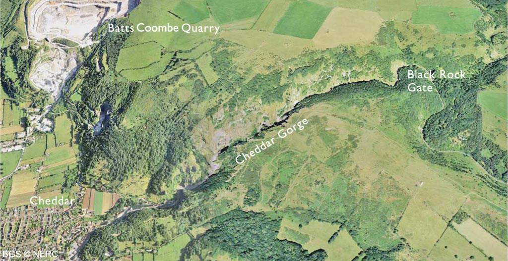
Cheddar Gorge
Cheddar Gorge is the finest example of a limestone gorge in Britain, and its cliffs support many valuable semi-natural habitats, home to a wide range of plant species, many of them rare. At the lower end of the gorge are two show caves which together attract half a million visitors a year.
The gorge
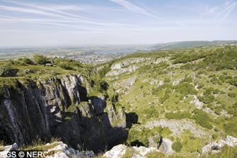
Contrary to popular belief, Cheddar Gorge is not a collapsed cavern, but a fine example of a gorge cut by a surface river, and since left high and dry as drainage went underground. The gorge was formed by meltwater floods during the many cold periglacial periods over the last 1.2 million years. During these arctic episodes, the development of permafrost blocked the caves with ice and frozen mud. Snowmelt floods during the brief summers were forced to flow on the surface, carving out the gorge in the process.
Each successive periglacial episode caused further erosion. During the warmer interglacial periods, drainage was underground, creating the caves and leaving the gorge dry.
Geology

The Gorge is cut into the Carboniferous Limestone, which here dips at about 20° to the south-west. As you travel down the gorge the dip causes successively younger rocks to descend to road level. The pale grey Burrington Oolite. outcrops around Black Rock Gate, while most of the gorge is cut into the Clifton Down Limestone (including the Cheddar Limestone and Cheddar Oolite). At the base of the gorge the Oxwich Head Limestone occurs at road level. The cliffs on the south side are dominantly vertical, cut along major fractures whereas the northern slopes are formed along the dipping bedding planes.
Cheddar caves
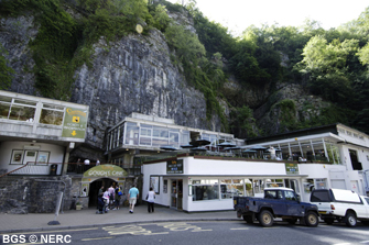
There are many mostly small caves in Cheddar Gorge, but the two largest, Gough's Cave and Cox's Cave are open to the public. Gough's Cave, discovered by Richard Gough in 1898, was formed by the ancestral River Yeo over 120 000 years ago. Just inside the entrance remains of several human skeletons, including the 9000-year-old Cheddar Man, were found along with many other archaeological artifacts.
The show cave follows the former route of the underground river through several well decorated chambers. The underground river has now found a new lower route, discovered by cave divers in 1985, and emerges to daylight at Cheddar Risings. Cox's Cave was discovered by George Cox in 1837 and contains many stalactites and stalagmites. Several other small caves exist in the cliffs above, remnants of earlier courses of the underground River Yeo, long since abandoned by down-cutting of the gorge. Many are home to roosting and hibernating bats, including significant numbers of the greater horseshoe bat.
Flora and fauna
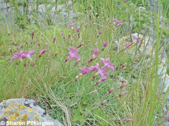
The limestone crags and cliff faces are home to many plant species, including slender bedstraw and lesser meadow-rue, and the rare and protected Cheddar pink. The thin dry limestone soils on south-facing slopes support grasslands which are important for insects and other invertebrates.
Quarrying
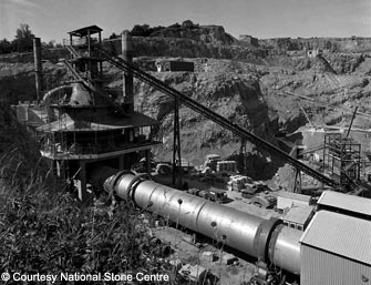
Several quarries once operated on the Cheddar area. The largest, Batts Coombe Quarry, is still operational. This quarry is developed in the Burrington Oolite, a very pure limestone (over 98% CaCO3), used for making quicklime, an essential material for the steel industry. It is one of only five sites producing the substance nationwide. Stone was once quarried from Cheddar Gorge but public opposition and a landslide caused the site to close down by 1912.
- Home
- Overview maps
- Locality
areas
- Cheddar Gorge
- Charterhouse
- Blackdown
- Burrington Combe
- Shipham & Rowberrow
- Crook Peak & Axbridge
- Banwell to Churchill
- Priddy
- Harptree & Smitham Hill
- Draycott & Westbury-sub-Mendip
- Wookey Hole & Ebbor Gorge
- Wells
- Great Elm & Vallis Vale
- Mells & the Wadbury Valley
- The Vobster area
- The Whatley area
- Torr Works & Asham Wood
- Beacon Hill
- Stoke St Michael & Oakhill
- Holwell & Nunney
- Shepton Mallet & Maesbury
- Gurney Slade & Emborough
- The Nettlebridge valley
- Geology
- Minerals and mines
- Quarrying
- Caves and karst
- Biodiversity
- Detailed site information
- Acknowledgements
- External links
- Search
- Site map