Banwell to Churchill
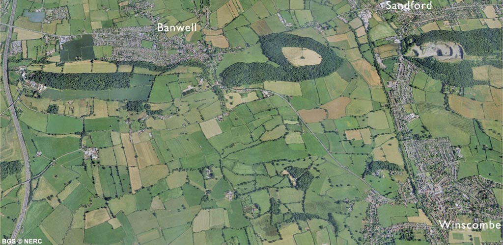
The northern flank of Mendip between Banwell and Dolebury is formed by a narrow discontinuous ridge of Carboniferous Limestone. This forms the steeply dipping northern limb of the Blackdown Pericline. The limestone ridge was initially formed during Triassic times and then buried beneath the Triassic Dolomitic Conglomerate and Mercia Mudstone infilling the Lox Yeo valley. Only in the last few million years has erosion exhumed the hard limestone beneath, in effect recreating the former Triassic landscape.
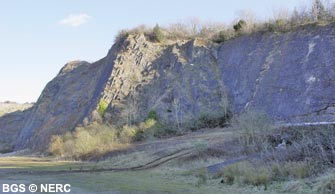
Overturned limestone
The Carboniferous Limestone is well exposed in quarries alongside the A38 at Churchill Batch. Here, the graffiti covered slabs of Burrington Oolite has been so severely folded that rocks have been overturned, and strata appear to dip to the south.
The transition from overturned rock to vertically bedded and then upright, northerly dipping strata can be seen in the cliffs further south along the A38. The fossiliferous Black Rock Limestone outcrops in the many crags and scree slopes on the south side of Dolebury Warren which is dominated by the Iron Age hill fort. The rocks here are very steeply dipping or even vertical.
Ochre and potato stones
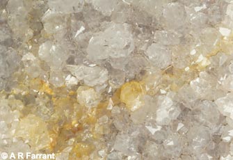
Evidence for old ochre workings can be seen in many places along the margins of the ridge between Banwell and Dolebury, particularly around Sandford. In places, small pits, spoil heaps and adits can be seen and specimens of ochre and quartz crystals, or 'Bristol Diamonds' can be found on the old spoil heaps. These quartz geodes, known locally as 'potato stones' are formed by the replacement of halite nodules by quartz. The halite (rock salt) nodules were originally deposited in ephemeral salt lakes during the Triassic, and evidence of these salt and gypsum deposits can still be found in the Mercia Mudstone.
Caves
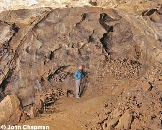
At the western end of Banwell Hill are two caves; Banwell Bone Cave and Banwell Stalactite Cave. Miners broke into Banwell Stalactite Cave in 1757, but the entrance collapsed and the cave was largely forgotten about. In 1824, an attempt to reopen the Stalactite Cave led to the discovery of Banwell Bone Cave. This cave consisted of a large chamber almost filled with sediment and containing many thousands of bones. The bones includes many cold climate species such as reindeer, brown bear, wolverine and arctic fox dating from the early part of the last glaciation about 80 000 years ago. The Bishop of Bath and Wells, George Henry Law, who owned the land, took the bones as wonderful evidence for Noah's Flood. Both caves are on private land but are occasionally open to the public. On Sandford Hill are several small caves and mine adits including Mangle Hole which intercepts the underground river feeding the springs in Banwell.
Quarrying
At the eastern end of Sandford Hill is the disused Sandford Quarry, which is developed mostly in the Burrington Oolite. In 1884, the quarry was a few small pits on the south side of the hill, but over the next 100 years expanded considerably into the western side of the hill. The quarry was closed in the 1990s as part of an arrangement to extend Whatley Quarry near Frome and parts of the site are now used for climbing and abseiling.
Flora and fauna
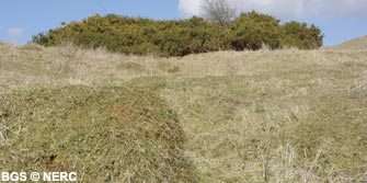
The nature reserve at Dolebury Warren is owned by the National Trust and managed by the Avon Wildlife Trust. This is an area of contrasting flower-rich limestone grassland and heathland, developed on acid loessic soils. Butterflies and insects are plentiful, especially on south-facing slopes where the conditions tend to be warmer.
- Home
- Overview maps
- Locality
areas
- Cheddar Gorge
- Charterhouse
- Blackdown
- Burrington Combe
- Shipham & Rowberrow
- Crook Peak & Axbridge
- Banwell to Churchill
- Priddy
- Harptree & Smitham Hill
- Draycott & Westbury-sub-Mendip
- Wookey Hole & Ebbor Gorge
- Wells
- Great Elm & Vallis Vale
- Mells & the Wadbury Valley
- The Vobster area
- The Whatley area
- Torr Works & Asham Wood
- Beacon Hill
- Stoke St Michael & Oakhill
- Holwell & Nunney
- Shepton Mallet & Maesbury
- Gurney Slade & Emborough
- The Nettlebridge valley
- Geology
- Minerals and mines
- Quarrying
- Caves and karst
- Biodiversity
- Detailed site information
- Acknowledgements
- External links
- Search
- Site map