Charterhouse
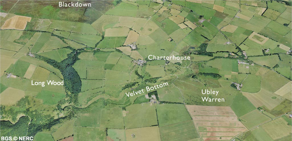
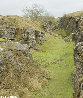
The Charterhouse area has a wealth of interesting geology, and evidence of a formerly extensive lead mining industry. Much of the area is a Site of Special Scientific Interest because of the rare lead-tolerant vegetation and for the cave systems beneath. Charterhouse is located on the narrow outcrop of the Avon Group mudstone between the Carboniferous Limestone plateau and the sandstone heath of Blackdown.
The gently dipping fossiliferous Black Rock Limestone can be seen around Velvet Bottom and Charterhouse, while further down valley towards Black Rock Gate the Burrington Oolite was quarried for lime.
Lead mining
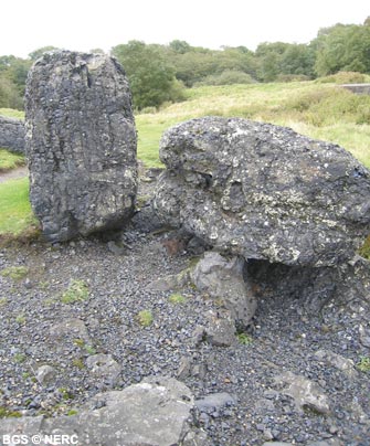
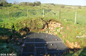
The Charterhouse area was an important lead mining area from Roman times until the 19th century. The remains of old lead workings can be seen around Velvet Bottom and Ubley Warren which are covered with 'gruffy' ground, a local name for uneven mined ground. The area contains worked-out mineral veins known as 'rakes', black glassy slag heaps, round stone-lined 'buddle' pits used for washing the ore, smelting plants, old flues and a complex network of dams and leats. Take care as there are old mineshafts! The miners were seeking lead ore, mostly galena (PbS), a heavy, grey, shiny, metallic mineral intermixed with the many calcite veins.
The lead was probably worked in the late Iron Age but it was in Roman times that the first serious mining took place. The Romans were mining in the Charterhouse area by AD 49, within six years of arriving in Britain. The heyday of mining was in the 17th and 18th centuries when many small shallow mines were dug. In 1844 Cornish miners began work in the Charterhouse area, trying to exploit the deeper ore. However, the ore deposits pinch out with depth, so instead, they resmelted the lead-rich waste or slag from earlier mining operations. Much of the present landscape including the piles of black glassy slag and the flues date from this time.
Flora and fauna
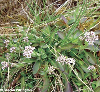
The long history of lead mining has created many valuable wildlife habitats. The slag heaps contain very low levels of plant nutrients and high levels of toxic heavy metals, especially lead, zinc and cadmium. A specialised community of metal-tolerant plants including sea campion, herb Robert and rare mosses and lichens have grown on these spoil heaps. One such plant, the rare alpine penny-cress is almost confined to sites rich in lead or zinc.
The worked out rakes support a diverse assemblage of different plant habitats. Here, loessic soils support acid-loving plants which grow next to lime-loving plants on the limestone crags and lead-tolerant species on the spoil heaps. A rich, varied, flora has developed, including the common spotted orchid, bee orchid, hutchinsia and brittle bladder-fern, and the nationally scarce soft-leaved sedge. Ubley Warren is also an important site for reptiles, with slow-worms, adders and common lizards all present. The rabbit-cropped limestone turf supports a wide diversity of herbs, grasses and wildflowers which attract many insects especially butterflies and grasshoppers. Ash and hazel woodland clothes the steep and rocky slopes near the top of Cheddar Gorge, which also support many ferns, mosses and liverworts.
The ponds and wetlands support distinctive aquatic flora and fauna such as mare's-tail, amphibious bistort, water-starwort and marsh marigold. The pools are also important for dragonflies and damselflies and a wide range of other invertebrate fauna.
Caves
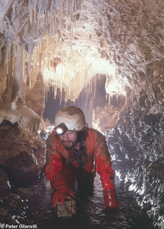
The Charterhouse area contains several extensive cave systems where water draining the sandstone slopes of Blackdown sinks underground at the contact with the Black Rock Limestone. These are only accessible to cavers.
The longest cave is Upper Flood Swallet near the car park at Charterhouse. This recently extended cave is now over 3 km long and extends under the rakes to the south. Another significant cave is Longwood Swallet in Long Wood, where the stream disappears underground. Cavers have explored more than 1600 m of passage extending to a depth of 175 m. Nearby is Rhino Rift, a vertical cave 145 m deep. The name derives from rhino and hyena teeth found near the entrance. At Manor Farm, another cave has been explored for over a kilometre and several smaller caves occur around Charterhouse including Waterwheel Swallet.
- Home
- Overview maps
- Locality
areas
- Cheddar Gorge
- Charterhouse
- Blackdown
- Burrington Combe
- Shipham & Rowberrow
- Crook Peak & Axbridge
- Banwell to Churchill
- Priddy
- Harptree & Smitham Hill
- Draycott & Westbury-sub-Mendip
- Wookey Hole & Ebbor Gorge
- Wells
- Great Elm & Vallis Vale
- Mells & the Wadbury Valley
- The Vobster area
- The Whatley area
- Torr Works & Asham Wood
- Beacon Hill
- Stoke St Michael & Oakhill
- Holwell & Nunney
- Shepton Mallet & Maesbury
- Gurney Slade & Emborough
- The Nettlebridge valley
- Geology
- Minerals and mines
- Quarrying
- Caves and karst
- Biodiversity
- Detailed site information
- Acknowledgements
- External links
- Search
- Site map