Lias
Geology of the Lias
The Lias consists of thick mudstones and clays with alternating bands of thin limestones. The fissured Marlstone Rock Bed yields small supplies of groundwater in the east Midlands.
The DECC (2012) 3.5 MB pdf report states that the Lias "though probably lying in the oil window ... is immature for shale gas ... the Lias is the source rock for the Weald Basin petroleum system and for the Wessex Basin, with migration into three different reservoirs in Wytch Farm oil field".
See also the Lias in the BGS lexicon of named rock units.
Area where the Lias is present
The distribution of the Lias is similar to that of the overlying Kimmeridge Clay and the Kellaways, Oxford Clay and Osgodby Formations. It is present continuously from the Yorkshire coast, along the eastern seaboard of England down to north Norfolk, through central southern England down to Dorset and throughout the Wessex basin and southern England.
Note that in the DECC (2012) report the Lias is described as being present to the west of the Bristol Channel, but in the relatively low resolution stratigraphy of the National Geological Model it has not been recorded in any section in south Wales and hence has not been mapped in this area for the present study.
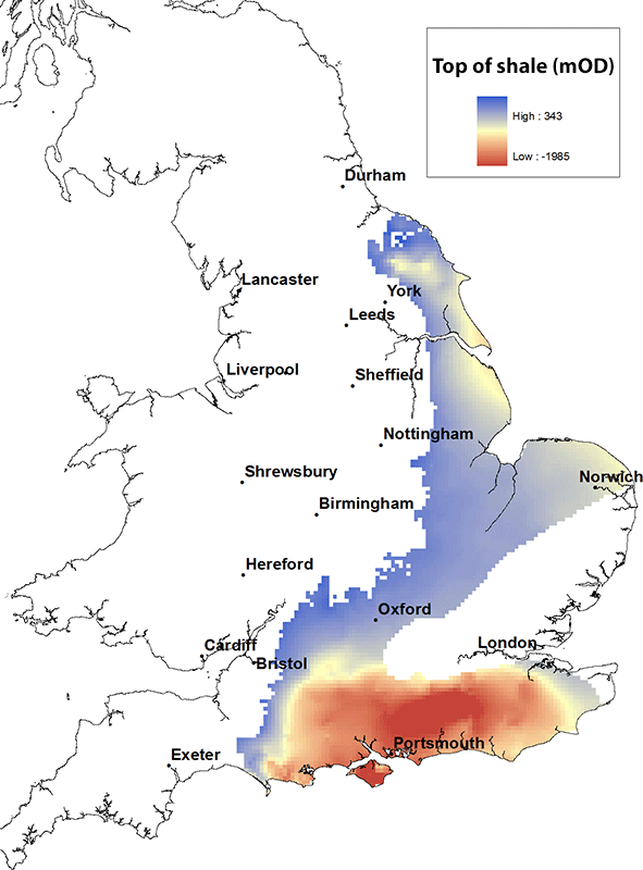
Elevation of the top of the Lias
The maximum height of the top of the Lias is about 300 m above OD. It is deepest within the centre of the Wessex Basin, where it reaches depths of almost 2000 m below OD.
Contact
Please contact BGS Enquiries for more information.


