Keeping an eye on groundwater levels — UK groundwater in February 2017
BGS scientists analyse groundwater levels across the UK each month. The variation in levels gives us insight into how much water is stored in aquifers, and can give advance warning of drought or flood.
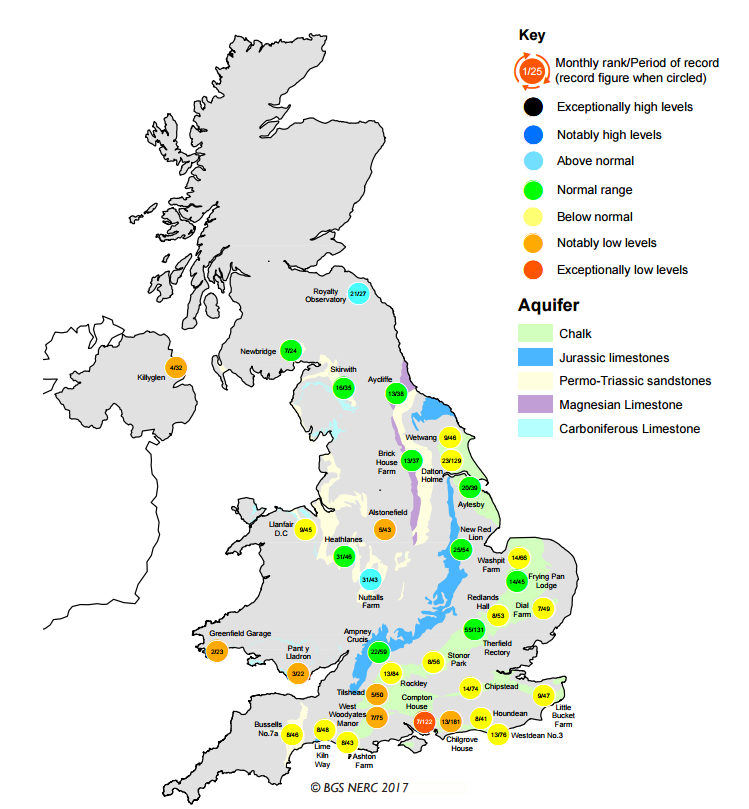
At the end of January 2017, groundwater levels were low across much of the UK, as shown in Figure 1. Groundwater levels usually rise during the winter months, but it was unusually dry over the preceding six months and the onset of groundwater recharge was significantly delayed across much of the UK.
South and south-east England, where the public water supply is particularly dependent upon groundwater sources, were most affected.
These low levels might have signified the onset of a groundwater drought, "the sustained and extensive occurrence of below average availability of groundwater". But, using data provided by the Environment Agency's network of observation boreholes that report levels in real time, we found that water levels rose in the first weeks of February, sharply in some places. It's currently too early to say whether this recovery will be sustained and whether it is sufficient to avoid concerns about low groundwater levels over the coming summer. This will depend upon the amount and distribution of rainfall we have over the next month or two.
Effect of early February rain
Our monthly review of groundwater levels for January 2017 shows a mixed picture, with many groundwater levels below average for the time of year (shown as yellow, orange and red spots on Figure 1), while others are in the normal range (green spots).
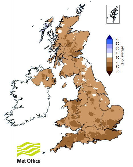
The long dry spell is apparent in the Met Office's map shown in Figure 2, showing the percentage of average rainfall over the period July 2016 to January 2017 (compared to 1981–2010 average). The rainfall deficit is most pronounced over the south and south-east on England.
Early February saw some wet weather in these dry areas, e.g. 41 per cent of average February rainfall (percentage of 1961–1990 average) fell on the south-east of England over the first week of February, with a similar value of 46 per cent in south-west England (Environment Agency weekly rainfall summary, 01–07 February 2017). We have subsequently seen groundwater levels rise in many observation wells, particularly in aquifers that respond quickly to rainfall.
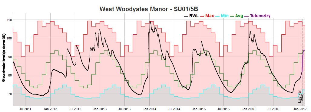
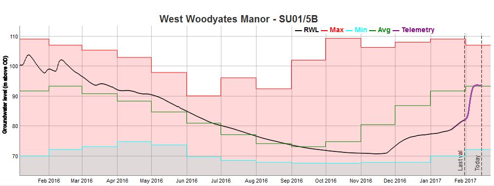
A typical example of the rise observed in a borehole sited in a responsive part of the Chalk aquifer is the hydrograph for West Woodyates Manor (Figures 3a and 3b). The West Woodyates Manor observation well is used to monitor groundwater levels in the Wessex Chalk aquifer between Blandford Forum and Salisbury. The groundwater level here rose from 'notably low' levels at the end of January 2017 (see Figure 1) to average (for the time of year) levels by mid-February. The groundwater level has since stopped rising as it stopped raining.
Will there be more groundwater recharge?
In a typical year, groundwater levels in the Chalk of southern England can start to rise in late September to October, and recharge would then continue until around mid-February to March, after which groundwater levels fall until the following autumn. The hydrographs in many observation wells are showing a different picture in 2017, with the rise in water levels only just beginning at the start of the year.
Groundwater recharge occurs when rainfall is able to soak through the soil and percolate down to an underlying aquifer. Once plants begin to grow in earnest, they take up a lot of available water, which is then either incorporated into the plant matter or released back to the atmosphere through transpiration. Whether or not we will see more groundwater recharge in 2017 will thus depend on the amount, location and timing of rainfall.
At BGS we will continue to keep an eye on these hydrographs: by comparing today's water levels with our historical records we can identify possible problems at an early stage.
What work is BGS doing on drought?
The BGS holds the National Groundwater Level Archive, which contains records of groundwater levels since the 1800s for a number of boreholes across the country.
These records enable us to look at the effect of previous periods of drought on groundwater systems, and to make predictions regarding the periodicity and duration of, and response to, future droughts.
Our future flows and groundwater levels project assessed the impact of climate change on river flows and groundwater levels across England, Wales and Scotland, using the latest probabilistic climate projections.
Long-term analysis
We are also working with partners to improve monitoring for long-term analysis of groundwater levels across the UK. This will help us to assess and understand the potential impact of long-term climate change on groundwater and surface water levels.
The BGS has an active programme of groundwater drought research in the UK and internationally.
Our sister organisation the Centre for Ecology & Hydrology holds information on surface water flows and drought.
Contact
Please contact BGS Enquiries


