Chalk/Kellaways, Oxford Clay and Osgodby Formation separation map
Area where both aquifer and shale are present
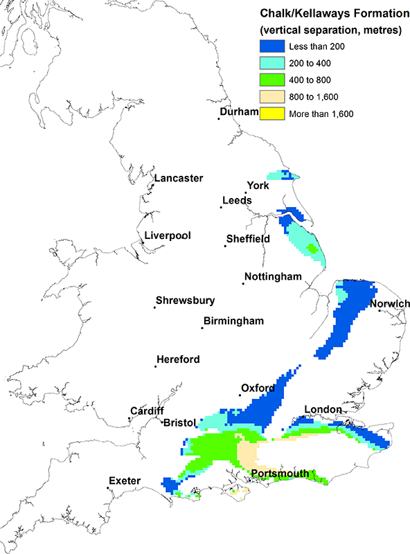
In north Yorkshire, around the Humber and Lincolnshire, Norfolk and Cambridgeshire, Bedfordshire to Dorset and around the Weald.
Note that for the purposes of drafting this separation map the maximum depth of the Chalk aquifer is taken to be 400 m below ground level based on the recommendations in the UK TAG report (UK TAG, 2011). More information about this can be found in the methods section.
Thickness of intervening strata
North Yorkshire: 150 to 300 m.
Around the Humber and Lincolnshire: up to about 450 m, generally increasing south eastwards.
Norfolk and Cambridgeshire: 30 to 250 m decreasing south and eastwards.
Bedfordshire to Dorset and around the Weald: 30 to 1500 m thickest adjacent to the Weald and south eastwards on the Isle of Wight.
Lithology of intervening strata
North Yorkshire: permeable Corallian (principal aquifer), low permeability Kimmeridge and Ampthill Clays (clay), low permeability Speeton Clay and mixed permeability Lower Cretaceous sediments.
Around the Humber and Lincolnshire: low permeability Kimmeridge and Ampthill Clays (clay), permeable Spilsby Sandstone (principal aquifer), permeable Wealden sandstones, low permeability Wealden limestone and permeable Lower Greensand (principal aquifer).
Norfolk and Cambridgeshire: low permeability Kimmeridge and Ampthill Clays (clays), permeable Wealden sandstones, permeable Lower Greensand (principal aquifer), mixed permeability Gault (clay) and Upper Greensand.
Bedfordshire to Dorset and around the Weald: permeable Corallian (principal aquifer), low permeability West Walton, Kimmeridge and Ampthill Clays (clays), permeable Portland, permeable Purbeck, low permeability Wealden, Lower Greensand (principal aquifer), mixed permeability Upper Greensand and Gault (clay).
Other major aquifers in the area
North Yorkshire: Triassic sandstones (below), Magnesian limestone (below).
Around the Humber and Lincolnshire: Oolites (below), Triassic sandstones (below), Magnesian limestone (below) Carboniferous Limestone (below).
Norfolk and Cambridgeshire: Crag (above), Oolites (below), Permian sandstones (below), Triassic sandstones (below), Carboniferous Limestone (below).
Bedfordshire to Dorset and around the Weald: Oolites (below), Permian sandstones (below), Triassic sandstones (below), Carboniferous Limestone (below).
Other shales or clays in the area
North Yorkshire: Lias (below) and Bowland High and Craven Groups (below).
Around the Humber and Lincolnshire, Norfolk to Cambridgeshire, Bedfordshire to Dorset and around the Weald: Lias (below).
Links to aquifer and shale/clay maps
View the map of the Chalk principal aquifer.
View the map of the Kellaways, Oxford Clay and Osgodby Formation.
References
UK TAG. 2011. Defining and reporting on groundwater bodies. UK Technical Advisory Group on the Water Framework Directive, working paper V6.21/Mar/2011
Contact
Please contact BGS Enquiries for more information.


