Scottish groundwater chemistry data: Pre-Baseline

There was little information on natural groundwater chemistry in Scotland before the Baseline Scotland project. Existing data was mainly old, of variable quality, limited (often to a few major ions only), and skewed to areas of groundwater contamination, particularly related to mining.
At the start of the Baseline project, previous studies of groundwater chemistry and available groundwater chemistry data in Scotland were reviewed by BGS (MacDonald and Ó Dochartaigh, 2005).
Fewer than 500 good quality major ion analyses were identified, biased towards the more productive Scottish aquifers, in particular the Devonian aquifers of Fife, Strathmore and Morayshire, and the Dumfries Permian aquifer.
Limitations of existing data
The pre-Baseline groundwater chemistry data were subject to a thorough quality assurance assessment. Poor quality data were removed, and the remaining data divided into logical divisions, based on concentration categories, to help make interepretation more robust.
Main limitations of the data:
- Out of the 800 sampling sites, only 428 sites had a full major ion chemistry with an error in ionic balance of less than 10%.
- Of these 428 sites, only 31 sites had a wellhead measurement of dissolved oxygen, and only 103 had a wellhead measurement of redox potential.
- Information on trace elements was generally limited. For arsenic and fluoride (two of the trace elements in groundwater generally considered the greatest risk to human health) data are particularly limited: only 65 good quality measurements of arsenic and 149 of fluoride exist. Only iron and manganese had more than 200 measurements across Scotland. The quality of the data is also highly variable, particularly related to sampling procedure: for example, many samples were not filtered on site.
- The dataset is highly skewed, with most good quality data available for the most heavily exploited aquifers: the Devonian aquifer in Fife and parts of Morayshire, and the Permian aquifer in Dumfries. There are few data available for Precambrian or Lower Palaeozoic aquifers.
Conclusions drawn from preliminary data
Major ion data
Major ion data were used to characterise Scottish groundwaters.
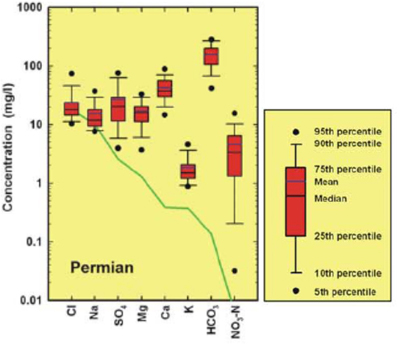
Permian aquifers
Groundwaters from the Permian sedimentary aquifers in Scotland have well defined chemistry and the least variation in concentrations of major ions of all Scottish groundwaters. Groundwater is typically of Ca-Mg-HCO3 type with a narrow range in the Mg/Ca ratio, and near-neutral pH.
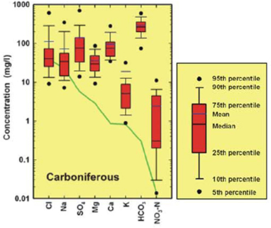
Carboniferous aquifers
The most highly mineralised groundwater in Scotland is found in Carboniferous aquifers. There is a marked bimodal distribution for Cl and Na which may indicate mixing with formation water. SO4 concentrations are considerably higher than for other aquifers, which may reflect the oxidisation of sulphide minerals within mudstones and the legacy of coal mining.
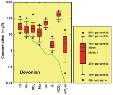
Devonian aquifers
Devonian groundwaters tend to be of Ca-HCO3 to Ca-Mg-HCO3 type and show a wider range in Mg/Ca ratio than for Permian groundwaters, but similar HCO3 concentrations (median Devonian HCO3 178 mg/l, median Permian HCO3 157 mg/l). The median pH of Devonian groundwaters is 7.5.
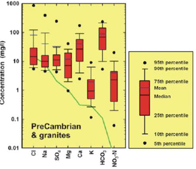
Precambrian, Silurian/Ordovician and superficial aquifers
The available data for superficial deposits, Precambrian and Silurian/Ordovician aquifers indicate a similar variability of major ion chemistry. This may reflect the short residence time of much of the water, and the high proportion of samples from springs and shallow wells. The waters are typically weakly mineralised, with pH less than 7.
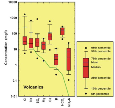
Volcanic aquifers
Groundwaters in volcanic aquifers are generally of Ca-HCO3 type, and similar to the sandstone aquifers, with the exception of K which varies considerably across the volcanic aquifers. A small proportion of samples have elevated Cl, Na, SO4 and Ca concentrations.
Trace element data
There are insufficient reliable data to identify clear trends in the concentration of trace elements in Scottish groundwater. However, some potential trends can be highlighted:
- Fe and Mn concentrations greater than the EC maximum permissible values are observed in all hydrogeological units in Scotland. Fe and Mn are ubiquitous in rocks, and the dominant controls on their presence in groundwater are the pH and redox status.
- The limited data for Al indicate that concentrations can approach or exceed the EC maximum permissible value for drinking water in Precambrian, volcanic and granite aquifers. This is linked to the acidic conditions of groundwater in these environments.
- The available data indicate that natural Cr concentrations in Scottish groundwater are typically well below the EC maximum permissible value, and usually below detection limit. However, there are no data from the Glasgow area, where elevated Cr concentrations in groundwater could be expected, due to the known historical contamination from the chrome and steel industry.
- F concentrations greater than 0.5 mg/l have been measured in samples from Permo-Triassic sandstone aquifers in both Morayshire and in Mauchline in south-west Scotland. Apart from these, several isolated samples scattered throughout Scotland showed F concentrations greater than the EC maximum permissible value of 1.5 mg/l.
Reports
More detail on the data summarised above is given in the report:
MacDonald A M and Ó Dochartaigh B É. 2005. Baseline Scotland: an overview of available groundwater chemistry data. British Geological Survey Commissioned Report CR/05/239N. British Geological Survey.
Another report output from the Baseline Scotland project provides an estimate of the potential distribution of trace elements in Scottish groundwater from proxy geological and geochemical information:
MacDonald A M, Fordyce F M, Shand P and Ó Dochartaigh B É. 2005. Using geological and geochemical information to estimate the potential distribution of trace elements in Scottish groundwater. British Geological Survey Commissioned Report CR/05/238N. British Geological Survey.


