Aberdeenshire

A total of 37 samples from Precambrian and igneous aquifers in Aberdeenshire are included in the Baseline dataset, collected between 2004 and 2006 (see map below). The sites for samples were chosen so that the Baseline data would be representative of groundwater across Aberdeenshire, within each of the studied aquifer types.
Four aquifer groups have been identified: three divisions of metamorphic aquifers of Dalradian age, the Appin, Argyll and Southern Highland Groups; and a single group incorporating all the intrusive rocks – largely granitic – across the region.
Download the Baseline Scotland: groundwater chemistry of Aberdeenshire report.
Main findings
The collection and interpretation of new groundwater chemistry data for southern Scotland has led to the following conclusions:
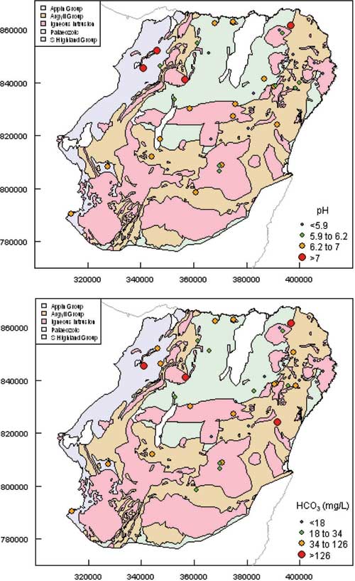
- Most of the groundwater pH values in the region are slightly acidic (5.5–7.2). Groundwaters from the Appin Group tend to have slightly higher pH (median pH 6.7) than those from the other aquifer groups (median pH values 6.2–6.3).
- Bicarbonate alkalinity: most groundwaters have relatively low bicarbonate concentrations, with a range from 11 to 127 mg/L (10th to 90th percentiles), and a median of 34 mg/L. Similar patterns to pH are observed between the aquifer groups, with HCO3 generally higher (median 80 mg/L) in Appin Group groundwaters, than in the others (medians 19 to 34 mg/L).
- Cl and SO4 concentrations are generally low, but because of the relatively low mineralisation of the Aberdeenshire groundwaters, Cl can constitute a relatively large proportion of the total dissolved anions, particularly in the Argyll and Southern Highland groups and in the igneous aquifers. The most significant source of Cl is likely to be maritime rainfall.
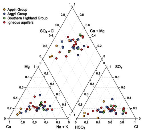
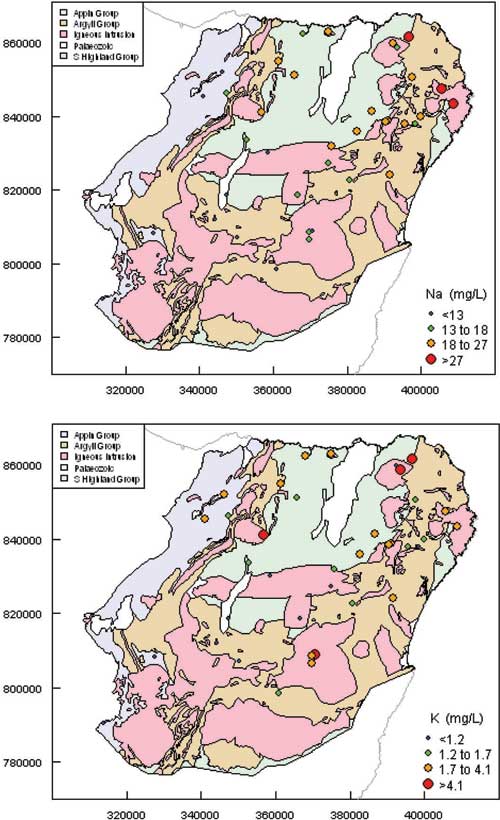
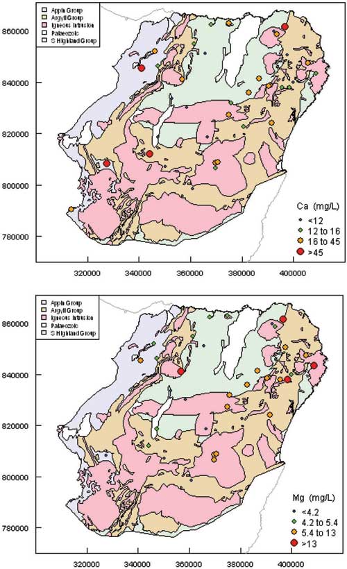
- Concentrations of the major cations reflect a combination of rainfall input, mineral weathering, and anthropogenic inputs derived from the use of fertilisers and liming, or from other sources of pollution. Most notable is a relative enrichment in bicarbonate and calcium, and more generally alkaline conditions, in groundwaters from the Appin Group compared to the other aquifer groups. All the groundwaters are undersaturated with respect to calcite, reflecting the general lack of carbonate minerals in the bedrock. The few samples close to saturation were derived from the Appin and Argyll Groups, which both contain calcareous rock bands.
- All of the groundwaters in the study area are oxidising, with dissolved oxygen concentrations generally in the range 3.9–9.6 mg/l and a redox potential (Eh) greater than 300 mV. This reflects the unconfined nature of the aquifers and the generally rapid groundwater flow.
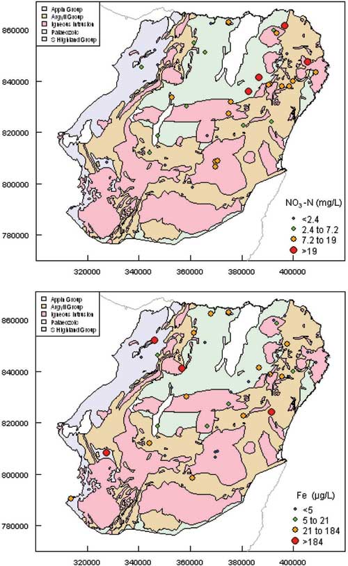
- Nitrate concentrations are highly variable: the median concentration of nitrate in groundwater is 7.15 mg/l NO3-N across the aquifers. Concentrations are related to land use, with groundwaters beneath agricultural land showing higher concentrations than those beneath non-agricultural land. The land use class showing the highest median NO3 concentration (13.6 mg/L NO3-N, compared to less than 7.6 mg/L NO3-N for other land use classes) was land used for rearing dairy, pigs and/or poultry.
- Concentrations of phosphorous in groundwater can be an important influence on surface water eutrophication if present in baseflow to streams and rivers. Concentrations in Aberdeenshire generally range from 20 to 80 mg/L-P. Although a slightly higher proportion of relatively low P concentrations occur in samples from areas of woodland and natural land use than from agricultural land, there isn't a strong relationship between P and land use, illustrating the complexity of P geochemistry, and the important role that soil geochemistry plays in the mobilisation of P into groundwater.
Interpretations in terms of groundwater flow in southern Scotland
The hydrochemical data and information on groundwater residence times can help give an insight into groundwater flow in aquifers across Aberdeenshire. The best interpretation of the groundwater flow system within all of the aquifers is that it is largely through fractures, except in areas of enhanced, deep weathering, where intergranular permeability is likely to have been enhanced and intergranular groundwater flow may dominate.
Groundwater is well mixed in the top 50 metres or so. There is no evidence of palaeowater in the area, and all samples (where CFC and SF6 have been measured) recorded some proportion of water less than 50 years old. However, groundwater can be resident for several decades, even in the fractured, low permeability aquifers.
Data
Summary statistics
The tables below provide a statistical summary of the natural variation in groundwater chemistry in all aquifers across Aberdeenshire: the Dalradian metamorphic aquifers (the Appin, Argyll and Southern Highland groups) and the igneous (mainly granitic) aquifers. Data between the 10th and 90th percentiles for each element or ion are presented, which allows the influence of outliers to be minimised. We would expect new data to plot within this range 80% of the time.
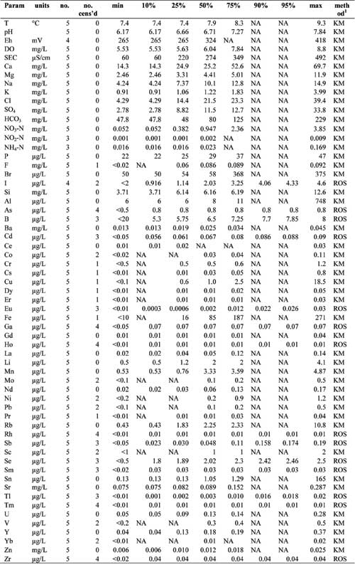
- Appin Group aquifer – Summary statistics of groundwater chemistry
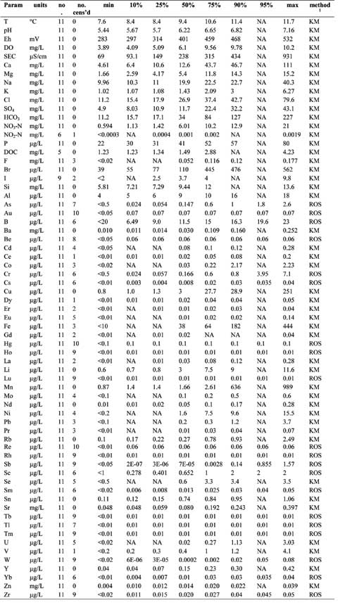
- Argyll Group aquifer – Summary statistics of groundwater chemistry
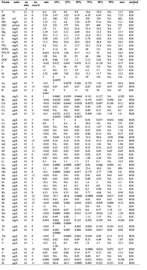
- Southern Highland Group aquifer – Summary statistics of groundwater
- Intrusive aquifers – Summary statistics of groundwater
- Piper diagrams illustrate the distribution of groundwater chemistry data for the four main aquifers, and indicate outliers.
Maps of regional variation in selected ion concentrations
- pH and HCO3 — Maps illustrating spatial variation in the concentration
- Na and K — Maps illustrating spatial variation in the concentration
- Ca and Mg — Maps illustrating spatial variation in the concentration
- NO3-N and Fe — Maps illustrating spatial variation in the concentration
- Mn and F — Maps illustrating spatial variation in the concentration


