Download digital groundwater maps of the Indo-Gangetic basin
The transboundary aquifer maps on groundwater abstraction, groundwater-level trend, salinity and arsenic and estimated groundwater storage are available for download. Each map is available as a 1 km resolution grid (xyz ASCII file), and also as high-resolution PDF files.
The maps provide new, higher-resolution information of the IGB aquifer, at transboundary scale, than previously available. They are based on a major systemic review of the best available, in situ observations and studies across the Indo-Gangetic alluvial aquifer. They are designed to show information at basin or regional scale.
Detailed description of the methodology and a full list of data sources used to develop the groundwater storage and productivity maps can be found in the peer-reviewed paper, published in Nature Geoscience.
Please read the terms and conditions of usage of the maps.
Groundwater-level trends
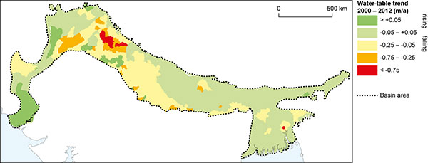
Figure 1 is a map of mean annual change in water-table levels across the aquifer during the period 2000 to 2010 (metres/year).
Groundwater abstraction
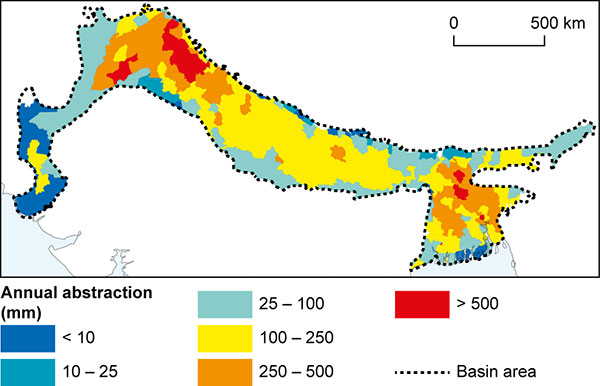
Figure 2 is a map of estimated mean annual groundwater abstraction across the aquifer based on data from 2010.
Groundwater storage change
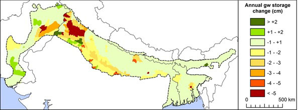
Figure 3 shows a map of estimated mean annual groundwater storage across the aquifer based on annual groundwater-level change and specific yield.
Groundwater quality
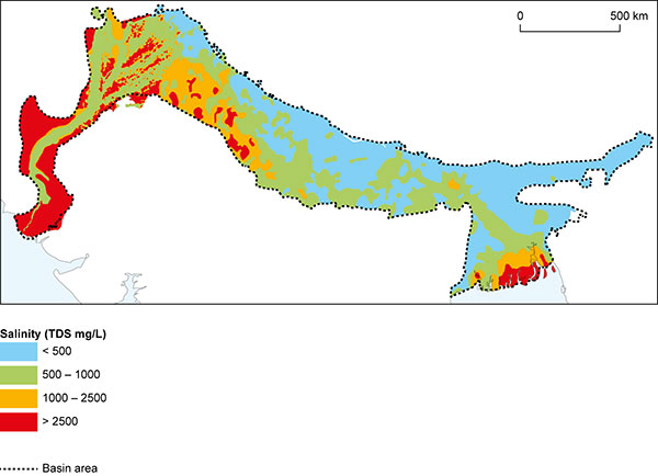
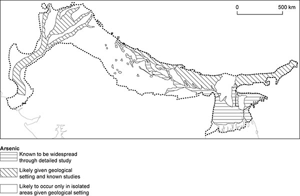
Figures 4 and 5 show salinity measured as total dissolved solids in the groundwater across the aquifer and areas where arsenic is known to be widespread, or thought likely to occur.
Reference for the dataset
MacDonald, A M, Bonsor, H C, Ahmed, K M, Burgess, W G, Basharat, M, Calow, R C, Dixit, A, Foster, S S D, Gopal, K, Lapworth, D J, Lark, R M, Moench, M, Mukherjee, A, Rao, M S, Shamsudduha, M, Smith, L, Taylor, R G, Tucker, J, van Steenbergen, F, Yadav, S K. 2016. Groundwater quality and depletion in the Indo-Gangetic Basin mapped from in situ observations. Nature Geoscience, doi:10.1038/ngeo2791.
Contact
Contact Alan MacDonald for further information

