Arsenic contamination of groundwater in Bangladesh

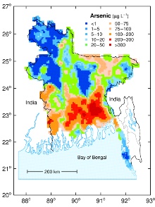
Groundwater contamination by arsenic was first discovered in the west of Bangladesh in late 1993 following reports of extensive contamination of water supplies in the adjoining areas of West Bengal, India.
Groundwater studies for arsenic contamination in Bangladesh project
The project 'Groundwater Studies for Arsenic Contamination in Bangladesh' was a reconnaissance investigation of the arsenic problem, carried out over the period 1998 to 2001. Its remit was to collate available data and conduct new groundwater surveys.
The project was funded by the UK Department for International Development (DFID). One of the main aims of the investigation was to assess the scale of the groundwater arsenic problem in order to aid the rapidly developing arsenic mitigation programme.
A second aim was to increase our understanding of the origins and behaviour of arsenic in Bangladesh aquifers. These aims were subsequently expanded to include a broader range of hydrochemical parameters.
The project was carried out in a collaboration between a number of organisations. On behalf of the Government of Bangladesh, DFID appointed the British Geological Survey (BGS) as lead consultants for the study. The Department of Public Health Engineering (DPHE), which is responsible for water supply throughout the country other than in the cities of Dhaka and Chittagong, was the executing agency. The Bangladesh Water Development Board (BWDB) and Geological Survey of Bangladesh (GSB) also provided counterparts.
The project was carried out in two phases: an initial six-month 'Rapid Investigation Phase' (Phase 1), and a subsequent 18-month Phase 2.
Phase 1: Rapid investigation phase
The BGS appointed Mott MacDonald Ltd (MML) to carry out much of the Phase 1 work and a team of national experts was recruited to assist. A report from the Phase 1 investigations was completed in 1999.
Phase 2: Groundwater surveys and more detailed investigations

Hydrochemical surveys were undertaken at various scales — national, upazila and village.
Two national-scale surveys were undertaken:
- a systematic survey of 61 of the 64 districts of Bangladesh involving the collection of 3534 tubewell samples
- a survey of 113 tubewells from the national water quality monitoring network maintained by the Bangladesh Water Development Board (BWDB)
Three upazilas (the sadar upazilas of Nawabganj, Faridpur and Lakshmipur districts) were also selected as Special Study Areas for a broader range of investigations.
In one of these upazilas, a single mouza or village (Mandari, Lakshmipur) was selected for a detailed survey using on-site arsenic analysis with an Arsenator. A limited amount of monitoring (time series) data were also collected from tubewells and piezometers in the three Special Study Areas.
Full details of the outputs from the Phase 2 project are available:
Use of material from the BGS and DPHE project 'Arsenic contamination of groundwater in Bangladesh'
Permission for reproduction of materials contained in these web pages is granted subject to the inclusion of the following acknowledgement:
'This material was produced by the British Geological Survey and the Department of Public Health Engineering (Bangladesh) undertaking a project funded by the UK Department for International Development (DFID). Any views expressed are not necessarily those of DFID'. In cases where only a map or diagram is reproduced or where data from the report are used, the above acknowledgement may be substituted by a full citation to the report as follows:BGS and DPHE. 2001. Arsenic contamination of groundwater in Bangladesh. Kinniburgh, D G and Smedley, P L (Editors). British Geological Survey Technical Report WC/00/19. British Geological Survey: Keyworth.
Contact
Contact Dr Pauline Smedley for further information


