Home
»
Our research
»
Groundwater science
»
Research areas
»
Groundwater and health
» Arsenic » Bangladesh » Data
Arsenic contamination of groundwater in Bangladesh: data
A series of downloadable data files are available. These data are included in the full Phase 2 report, but are presented here in CSV format.
- DPHE/BGS National Hydrochemical
Survey 850 KB CSV
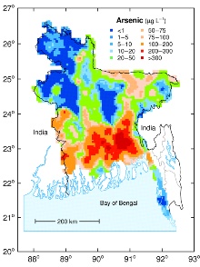
The results of the survey of 3534 boreholes from 61 of the 64 districts of Bangladesh. - Additional NHS data for
some trace elements in selected samples (by ICP-MS) 9 KB CSV
Some of the National Hydrochemical Survey samples were also analysed for a broader range of trace metals using ICP-MS. - BWDB Water Quality Monitoring
Network 45 KB CSV
The results of 113 boreholes from the BWDB Water Quality Monitoring network located throughout Bangladesh. - Special Study Areas 134 KB CSV
The results of the 271 boreholes and dug wells from the three Special Study Areas (Chapai Nawabganj, Faridpur and Lakshmipur). - Village survey 59 KB CSV
The results of the 236 boreholes from Mandari village in Lakshmipur district, SE Bangladesh.
Coastline data
- Bangladesh coastline
and districts 213 KB CSV
Approximate coastline and district boundaries in latitude-longitude format suitable for preparing water-quality maps.
Geological data
- Surface geology classification 176 KB CSV
Classification of National Hydrochemical Survey sample sites by surface geology according to the GSB map of Alam et al., 1990.
Contact
Contact Dr Pauline Smedley for further information
Research areas
Data, information and services
Research resources
People and collaborations
See also
External links
Contact


