Future Flows and Groundwater Levels: Regional groundwater model projections
Projections of changes in groundwater level have been generated using the BGS ZOOMQ3D regional groundwater model of the Marlborough and Berkshire Downs and south-west Chilterns. These projections have been based on:
- the 11-member ensemble of climate projections from the Met Office Hadley Centre's Regional Climate Model (RCM), and
- a subset of 1000 of the 10 000 probabilistic climate change factors for the 2050s under a medium (A1B) greenhouse gas emissions scenario.
ZOOMQ3D groundwater model
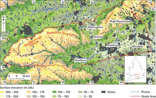
The modelled region is located 70 km west of London and covers an area of approximately 2600 square km. It encloses the Marlborough and Berkshire Downs and the south-western part of the Chilterns, which are areas of gently undulating Chalk downland. The River Thames flows onto the area, and the Chalk, near Wallingford and off the study area near Windsor.
The model is described in the following Journal of Hydrology article, which details its use in a previous climate change impact assessment study:
Jackson C R, Meister R & Prudhomme C. 2011. Modelling the effects of climate change and its uncertainty on UK Chalk groundwater resources from an ensemble of global climate model projections. Journal of Hydrology, 399, 12–28.
The model has been calibrated through comparison with measured groundwater levels at 207 observation boreholes and river baseflow at 20 gauging stations over the period 1971 to 2003. The calibrated model includes anthropogenic abstractions and discharges to and from rivers and the aquifer. Prior to the use of the model to make the projections, these abstractions and discharges are switched off. Consequently, all projections are based on a 'naturalised' system.
Summary of groundwater model projections
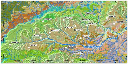
Projections of change in groundwater level are provided for the following observation boreholes:
| Name | Location | Easting | Northing |
|---|---|---|---|
| Ashridge Wood | SU47/140 | 449410 | 177910 |
| Axford | SU27/44 | 424530 | 171550 |
| Blind Man's Gate | SU46/139 | 443820 | 161780 |
| Bottom Farm | SU68/66 | 464780 | 183810 |
| Churn Estates | SU58/68 | 451640 | 185390 |
| Compton | SU57/154 | 452630 | 179390 |
| Gallowstree Common | SU68/22 | 469120 | 180210 |
| Gibbet Cottages | SU47/141 | 445480 | 178870 |
| Hodcott | SU48/69 | 448750 | 181750 |
| Letcombe Bowers | SU38/33 | 438490 | 182600 |
| Levetts Farm | SU16/2 | 417340 | 165670 |
| Membury House | SU37/17 | 430030 | 174700 |
| Old Hat | SU36/108 | 439900 | 165520 |
| Prebendal Farm | SU28/66 | 425900 | 181810 |
| Three Barrows | SU06/40 | 405790 | 167430 |
| Whitehouse | SU47/47 | 448870 | 171410 |
Downloads
11–member ensembles of transient 1951–2099 RCM projections under the medium (A1B) greenhouse gas emissions scenario
Ensembles of 1000 change factors for the 2050s under the medium (A1B) greenhouse gas emissions scenario
Spatial grids (.asc files) of change factors for the 11–member RCM ensemble for six 30-year time-slices (2030s to 2080s) under the medium (A1B) greenhouse gas emissions scenario at the end of March, June, September and December.
Images files (PNGs) of these spatial change factors for the 2050s
Contact
Contact Dr Chris Jackson for further information.


