Hyporheic zone research overview

Groundwater meets surface water
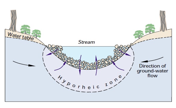
Interesting things happen when worlds collide and the zone where surface water and groundwater meet is no different.
Here, nutrients are consumed, unique creatures dwell and water moves down, up and sideways.
The hyporheic zone has a small volume compared to that of the overlying river or underlying aquifer, but it can have a big impact on water quality and ecology.
Hyporheic zone processes have wide impact
The Hyporheic Handbook , the product of a NERC-funded Knowledge Transfer Network, states that:
'The groundwater/surface water interface is the transitional zone between the subterranean and surface aquatic environments and it provides a number of ecological goods and services, including:
- controlling the location and flux of water exchange between stream and subsurface
- providing a natural attenuation zone for certain pollutants by biodegradation, sorption and dilution
- providing a habitat for benthic and interstitial organisms
- providing a spawning ground and refuge for certain species of fish
- providing a rooting zone for aquatic plants
- providing an important zone for the cycling of carbon, energy and nutrients
- moderating river water temperature
- providing a sink/source of sediment within a river channel.'
BGS research
Current and past BGS research aims to improve our understanding of hyporheic zone processes. This includes:
- Urban hyporheic zone — studying a tributary of the River Clyde in the south-east of Glasgow, where chromium (VI) contamination is an issue
- Hyporheic zone in mine impacted catchments — contaminated sediments in the hyporheic zone of mine impacted catchments may represent a significant source of diffuse pollution. Research has focused on a case study along a reach of the Rookhope Burn, a tributary of the River Wear.
- Eddleston: groundwater-surface water interaction on an upland floodplain — The Eddleston Water is a small, upland tributary of the River Tweed in the Scottish Borders, which has been selected as a demonstration research catchment by the Scottish Government for promoting Natural Flood Management.
- Groundwater and flooding in Oxford — The Groundwater and flooding in Oxford project is a collaboration between the BGS and the Environment Agency which has identified the factors that control groundwater flooding in the Oxford area and mapped areas prone to groundwater flooding.
- Groundwater studies of sandurs in Iceland — A sandur is a flat plain spreading out in front of a glacier, made up of unconsolidated and generally coarse-grained and probably highly permeable sediment that's been washed down by meltwater. The hydrogeological principles which govern groundwater-surface water interaction in temperate climates don't apply here.
- Lowland catchment research (LOCAR) — investigated how water enters, is stored within, and is discharged from rivers in three groundwater-dominated catchments, the Frome/Piddle in Dorset, the Pang/Lambourn in Berkshire and the Tern in Shropshire.
- Coastal dunes — we are working with colleagues at the Centre for Ecology and Hydrology (CEH) to inprove understanding of groundwater-surface water interaction in dune environments.
Publications
Lapworth, D J, Stolpe, B, Williams, P J, Gooddy, D C and Lead, J R. 2013. Characterization of suboxic groundwater colloids using a multi-method approach. Environmental Science and Technology, 47 (6). 2554-2561. 10.1021/es3045778
Palumbo-Roe, B, Wragg, J, and Banks, V. 2012. Lead mobilisation in the hyporheic zone and river bank sediments of a contaminated stream: contribution to diffuse pollution. Journal of Soils and Sediments, 12 (10). 1633-1640. 10.1007/s11368-012-0552-7
Lapworth, D J, Stolpe, B, Gooddy, D C, and Lead, J R. 2012. Characterising nanoparticles in sub-oxic environments. In: Interfaces against pollution, Nancy, France, 11–14 June 2012. 192. (Unpublished)
Stuart, M. 2012. Groundwater-surface water interactions. [Lecture] In: Better Thames: Workshop on Groundwater, Reading, UK, 18 April 2012. London, UK, Better Thames. (Unpublished)
Robins, N.S., Jones, M.L.M. 2012. Ecohydrological ‘indicators of alteration’: a robust measure of change in dune slacks. Ecohydrology. 10.1002/eco.1264
Lapworth, D., Gooddy, D., Jarvie, H. 2011. Understanding phosphorus mobility and bioavailability in the hyporheic zone of a chalk stream. Water, Air and Soil Pollution, 218 (1-4). 213-226. 10.1007/s11270-010-0636-1
Stuart, M, and Lapworth, D. 2011. A review of processes important in the floodplain setting. British Geological Survey, 32pp. (OR/11/030)
Allen, D J, Darling, W G, Gooddy, D C, Lapworth, D J, Newell, A J, Williams, A T, Allen, D and Abesser, C. 2010. Interaction between groundwater, the hyporheic zone and a Chalk stream: a case study from the River Lambourn, UK. Hydrogeology Journal, 18 (5). 1125–1141. 10.1007/s10040-010-0592-2
Lapworth, D J, Gooddy, D C, Allen, D, and Old, G H. 2009. Understanding groundwater, surface water and hyporheic zone biogeochemical processes in a Chalk catchment using fluorescence properties of dissolved and colloidal organic matter. Journal of Geophysical Research, 114, G00F02. 10, pp. 10.1029/2009JG000921
Contact
Contact Dr Daren Gooddy for further information.
- Using boreholes as windows into groundwater ecosytems
- Characterization of suboxic groundwater colloids using a multi-method approach
- Lead mobilisation in the hyporheic zone and river bank sediments of a contaminated stream: contribution to diffuse pollution
- Understanding groundwater, surface water and hyporheic zone biogeochemical processes in a Chalk catchment using fluorescence properties of dissolved and colloidal organic matter
- BGS catchment processes publications
- The Hyporheic Handbook [PDF, 13MB], the product of a NERC-funded Knowledge Transfer Network


