The European Groundwater Drought Initiative
The European Groundwater Drought Initiative, or GDI, is a three-year, NERC-funded project to assess and model groundwater drought status across Europe, investigate the impacts of groundwater drought, and to build a community to grow our understanding of the phenomenon of groundwater drought.
The project is being coordinated by John Bloomfield at the BGS and Anne Van Loon at the University of Birmingham.
How to contribute to the GDI
We are actively seeking partners to contribute to the GDI. Please get in touch with us if you would like to know more about the Initiative. We are particularly keen to hear from researchers who have an interest in understanding drought and extreme events in long groundwater level or spring-flow records, as well as researchers who have an interest in the impacts of groundwater droughts.
We are currently working with teams from across Europe, including:
- BOKU Vienna, Austria
- Center for Applied Ecology (CEABN) at ISA, University of Lisbon, Portugal
- Comenius University Bratislava, Slovakia
- Croatian Geological Survey (HGI-CGS), Croatia
- Environmental Protection Agency Ireland (EPA IE), Ireland
- Geological Survey of Denmark and Greenland (GEUS), Denmark
- Institute of Environmental Sciences and Water Research (CSIC), Spain
- University of Freiburg, Germany
- University of Latvia and Latvian Environment, Geology and Meteorology Centre (LEGMC), Latvia
- University of Oslo, Norway
- University of Rouen, France
- Wageningen University, The Netherlands
GDI also has the support of the International Groundwater Resources Assessment Centre (IGRAC/UNESCO).
Why are we studying groundwater droughts across Europe?
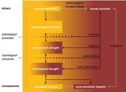
There are already services that provide information about the status of meteorological drought across Europe, and recently there have been significant advances in the understanding of drought in surface waters across Europe. However, until now there has been no attempt to bring together information related to the status of groundwater droughts at the continental scale (Van Loon, 2015).
There are significant benefits to be gained from analysing groundwater drought at the European scale. Major groundwater droughts take many months to develop, have large spatial footprints and typically lag behind the driving meteorology. This means that there is the potential to forecast the status of a developing groundwater drought and improve our planning for, and management of, these droughts.
GDI activities
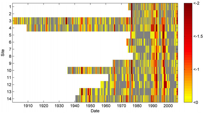
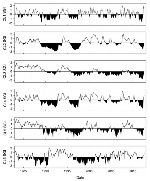
The first task of the GDI is to bring together many long-term (multi-decadal) groundwater level and spring flow records and standardise them using techniques such as the standardised groundwater level index, or SGI (Bloomfield and Marchant, 2013). Standardisation enables groundwater level data from disparate locations to be analysed in a consistent manner. For example, clusters of groundwater level and spring-flow hydrographs can be identified with similar responses to the driving meteorology (Bloomfield et al., 2015). Using the standardised hydrographs, we will describe and analyse the changing status of groundwater droughts across Europe on a monthly time step from the 1960s to the present. A particular aim of this analysis is to understand how catchment and local factors may modify the regional groundwater response to drought.
Two key planned GDI activities relate to the impacts of groundwater drought. We will be adding to and systematically analysing all groundwater-related impact information in the European Drought Impact Report Inventory (EDII) to understand how groundwater-drought impacts relate to the concept of drought in the Anthropocene (Van Loon et al., 2016a). We will also be undertaking a series of comparative case studies across Europe, in particular focusing on the differing characteristics as well as commonalities in the effects of groundwater droughts in northern Europe and more water-stressed regions of Europe, particularly in the south.
References and suggested reading
Bloomfield, J P, and Marchant, B P. 2013. Analysis of groundwater drought building on the standardised precipitation index approach. Hydrology and Earth System Sciences, 17(12), 4769–4787.
Bloomfield, J P, Marchant, B P, Bricker, S H, and Morgan. 2015. Regional analysis of groundwater droughts using hydrograph classification. Hydrology and Earth System Sciences, 19, 4327–4344.
Folland, C K, Hannaford, J, Bloomfield, J P, Kendon, M, Svensson, C, Marchant, B P, Prior, J, and Wallace, E. 2015. Multi-annual droughts in the English Lowlands: a review of their characteristics and climate drivers in the winter half year. Hydrology and Earth Systems Scien, 19, 2353–2375.
Rust, R, Holman, I, Corstanje, R, Bloomfield, J P, and Cuthbert, M. 2017. A conceptual model for climatic teleconnection signal control on groundwater variability in the UK and Europe. Earth Science Reviews, 177, 164–174.
Van Loon, A F. 2015. Hydrological drought explained. WIREs Water. doi: 10.1002/wat2.1085.
Van Loon, A F and Laaha, G. 2014. Hydrological drought severity explained by climate and catchment characteristics. Journal of Hydrology, 526, 2015, 3–14.
Van Loon, A F, Gleeson, T, Clark, J, Van Dijk, A, Stahl, K, Hannaford, J, Di Baldassarre, G, Teuling, A, Tallaksen, L M, Uijlenhoet, R, Hannah, D M, Sheffield, J, Svoboda, M, Verbeiren, B, Wagener, T, Rangecroft, S, Wanders, N, and Van Lanen, H A J. 2016a. Drought in the Anthropocene. Nature Geoscience, 9(2), 89–91.
Van Loon, A F, Gleeson, T, Clark, J, Van Dijk, A I J M, Stahl, K, Hannaford, J, Di Baldassarre, G, Teuling, A J, Tallaksen, L M, Uijlenhoet, R, Hannah, D M, Sheffield, J, Svoboda, M, Verbeiren, B, Wagener, T, Rangecroft, S, Wanders, N, and Van Lanen, H A J. 2016b. Drought in a human-modified world: reframing drought definitions, understanding and analysis approaches. Hydrology and Earth Systems Sciences, 20, 3631–3650.
Van Loon, A F, Kumar, R, and Mishra, V. 2017. Testing the use of standardised indices and GRACE satellite data to estimate the European 2015 groundwater drought in near-real time. Hydrology and Earth System Sciences, 21, 1947–1971.
Contact
For more information, please contact:
- John Bloomfield, BGS
- Anne Van Loon, University of Birmingham
- Bentje Brauns, BGS (GDI secretariat)
- Drought and community water supplies
- Groundwater management in drought-prone areas of Africa
- Groundwater security and drought in Africa: linking availability, access and demand
- Modelling the effects of climate change and its uncertainty on UK Chalk groundwater resources from an ensemble of global climate model projections
- Potential impact of climate change on improved and unimproved water supplies in Africa
- What impact will climate change have on rural groundwater supplies in Africa?


