The Chalk aquifer of the South Downs
Groundwater is an important component of the water resources of the South Downs. It is extensively used, but there are a number of pressures on the groundwater resources [in page link to Hydrogeology of South Downs] of the region. These include, groundwater pollution [in page link – see below] and intrusion of seawater into the aquifer [in page link]. In addition, parts of the South Downs have a history of flooding from groundwater [in page link]. BGS, in collaboration with partners, is working to improve our understanding the hydrogeology of the Chalk to address these issues. BGS published a memoir on the Chalk aquifer of the South Downs in 1999. This is available through the NERC Open Research Archive (NORA) . Here we summarise recent work in the region as well as some of the conclusions from the report.
Hydrogeology of the South Downs
The Chalk aquifer of the South Downs runs roughly parallel to the south coast of England between Eastbourne in the east and Pool harbour in the west. The Chalk is highest in the north of the area and dips south towards the English Channel. It is divided into five areas defined by a series of roughly north-south trending river valleys.
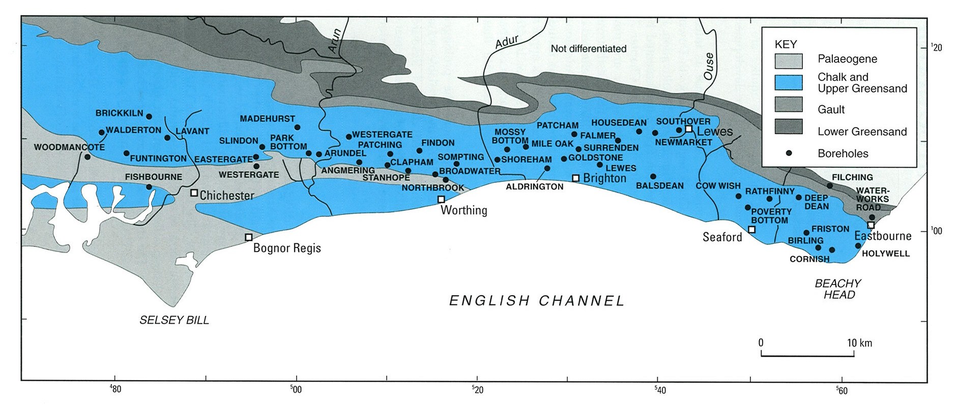
Rainfall over the area is about 700 mm a year, with recharge to the aquifer of about 300 mm a year. The maximum depth to groundwater is about 90 metres over the interfluves in the north. Seasonal and between year variations in recharge and groundwater level are recorded in the groundwater level hydrograph for Chilgrove House [link to GW hydrograph page]. This is the UKs longest continuous groundwater level time series with records going back to 1836.
The average aquifer transmissivity is about 450 m2 per day but is highly variable dependent on lithology, local geological structure and the degree of karstification, with values ranging from 16 to almost 10,000 m2 per day. Groundwater is generally of good quality, apart from the local effects of saline intrusion [in page link]. The mineral composition of groundwater is dominated by reactions involving CO2, and groundwater is typically saturated with calcite.

Groundwater Pollution and protection
The Chalk aquifer is susceptible to a variety of types of pollution, including point sources, typically found in urban environments, and diffuse pollution from a range of agricultural practices. Generally, however, in the South Downs, despite high population, extensive groundwater use and widespread agriculture, incidents of groundwater pollution are relatively rare.
Leachate migration from landfill sites can be source of pollution. However, the dual-porosity nature of the Chalk aquifer can act to dilute and disperse landfill plumes, and the carbonate rock provides a chemical buffer that reduces the mobility of some harmful components of the lechate such as heavy metals.
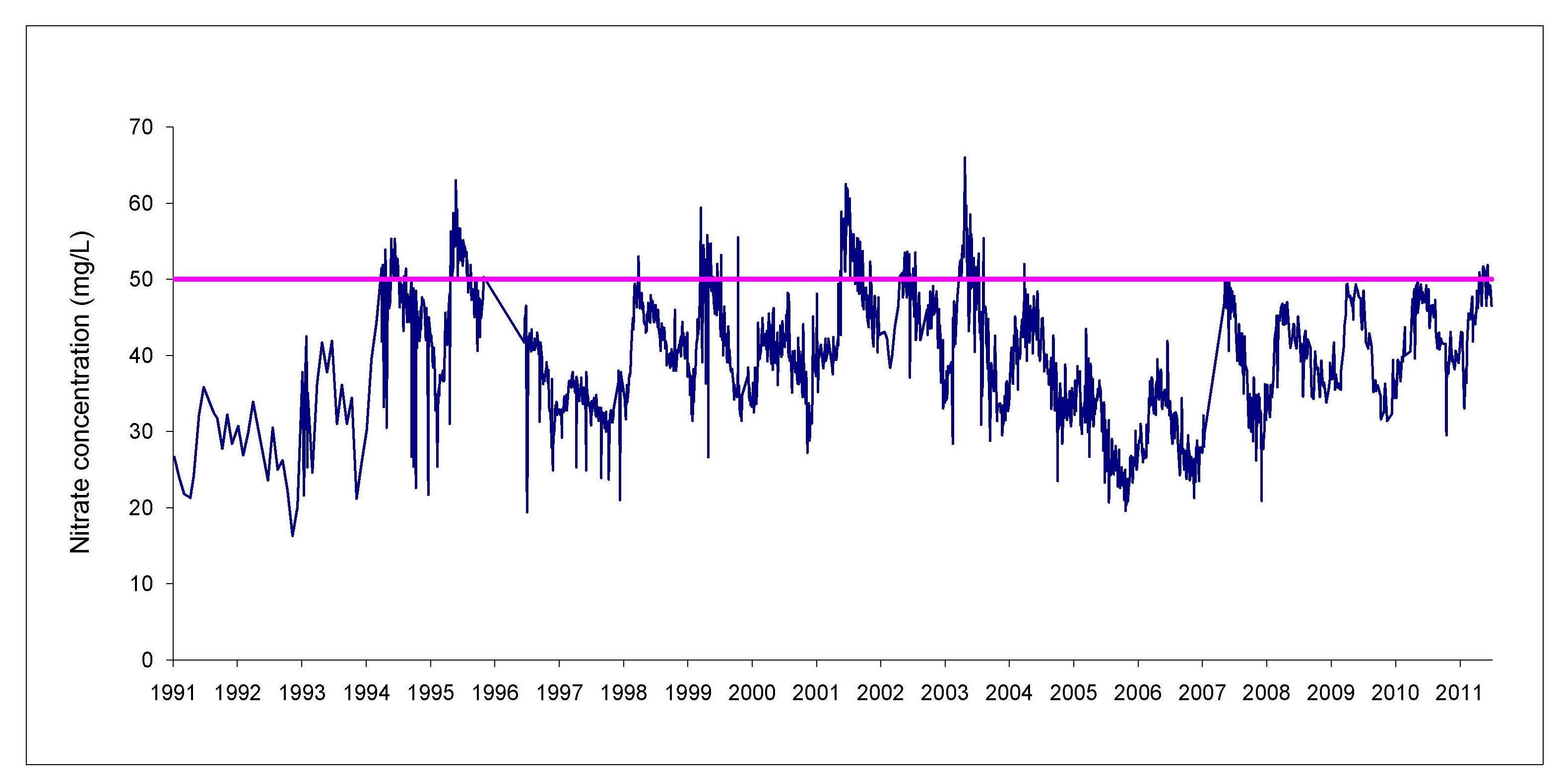
Diffuse pollution from agricultural application of pesticides and nitrate is common and widespread feature of the Chalk if England. Work in the South Downs has shown that at some sites there is a rising trend in nitrate [link to nitrate trends(?) page] concentrations in groundwater and seasonal variations in nitrate have also been seen, with highest concentrations in the early winter associated with the start of groundwater recharge.
Groundwater protection measures have been in place in parts of the area since the 1920s and are now extensive. These include controls on land use near groundwater abstraction boreholes, known as source protection zones, and a comprehensive aquifer protection policy based on assessments of the vulnerability of the aquifer to contamination.
Saline intrusion
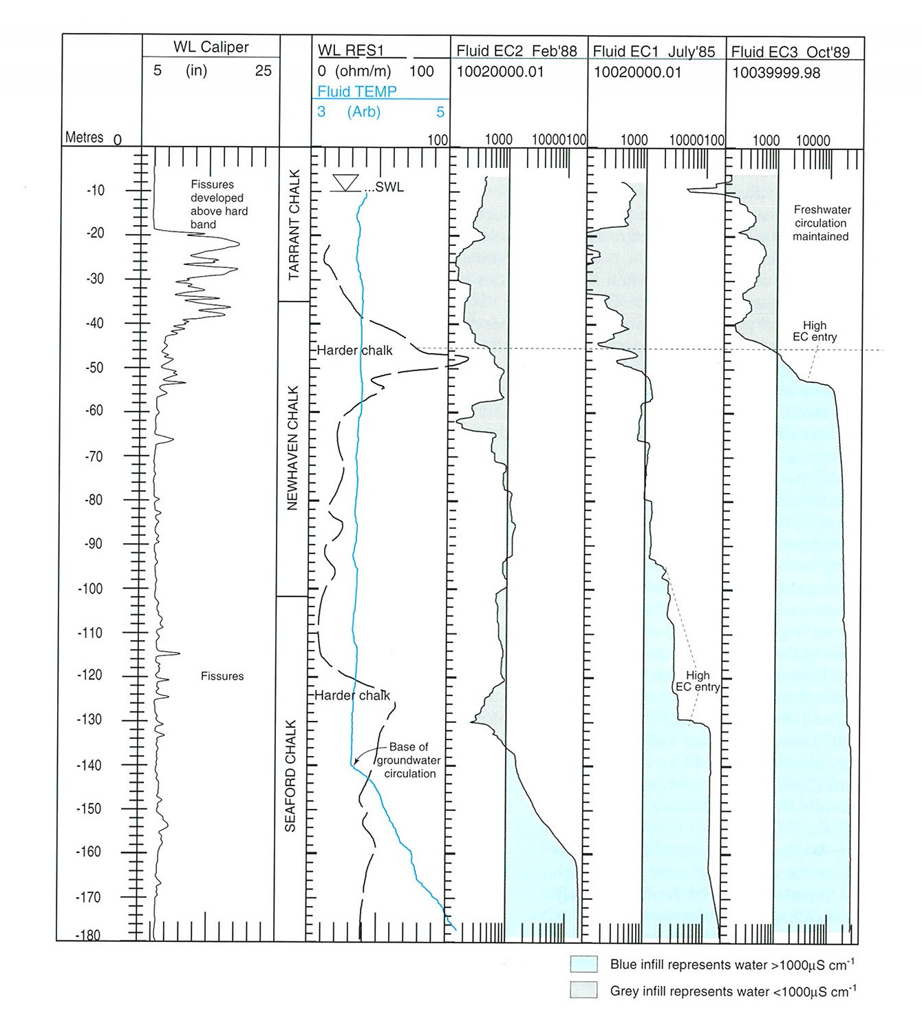
As the Chalk aquifer is in contact with the sea, particularly to the east, saline water may enter the aquifer to create a wedge of relatively dense saline water beneath the fresh groundwater. Borehole logging [link to bh geophysics page] has shown that saline intrusion mainly happens along horizontally oriented fractures, with seawater able to move considerable distances inland. However, detailed comparison of geophysical logs along the coast has shown considerable variation in the extent of saline intrusion even over short distances. In addition, large seasonal variations in the extent of intrusion have also been described. Saline intrusion has been actively managed since the late 1950s through preferential pumping of coastal boreholes.
Groundwater flooding
Locally the Chalk aquifer of the South Downs can be highly susceptible to groundwater flooding , and major flooding incidents occurred in the region at Chichester in 1994 and in Brighton in 2001. BGS has investigated the causes of flooding in the Chalk and specifically investigated groundwater flooding in Brighton as part of a European Union funded-project called FLOOD1.
Contact
Contact BGS Enquiries for further information.


