Zooming object oriented distributed recharge model (ZOODRM)
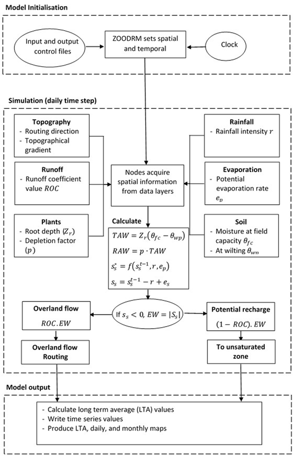
ZOODRM (Mansour and Hughes, 2004) is an Object Oriented model developed by BGS as part of the ZOOM suite of models. It is a distributed recharge model that simulates runoff and recharge processes and provides the output in a gridded form for use with groundwater flow models or on a catchment basis for water balance purposes. It has been applied in both the UK nationally, regionally and overseas (e.g. West Bank; China).
The model incorporates the UN Food and Agricultural Organisation (FAO) soil moisture balance method and a simplified version of this algorithm in addition to other methods that calculate recharge in specific environments such as semi-arid and urban environments. The model includes runoff routing, overland flow routing and storage, interaction with lakes and reservoirs, and rainfall interception.
Estimation of spatially distributed potential recharge
Application to the British mainland
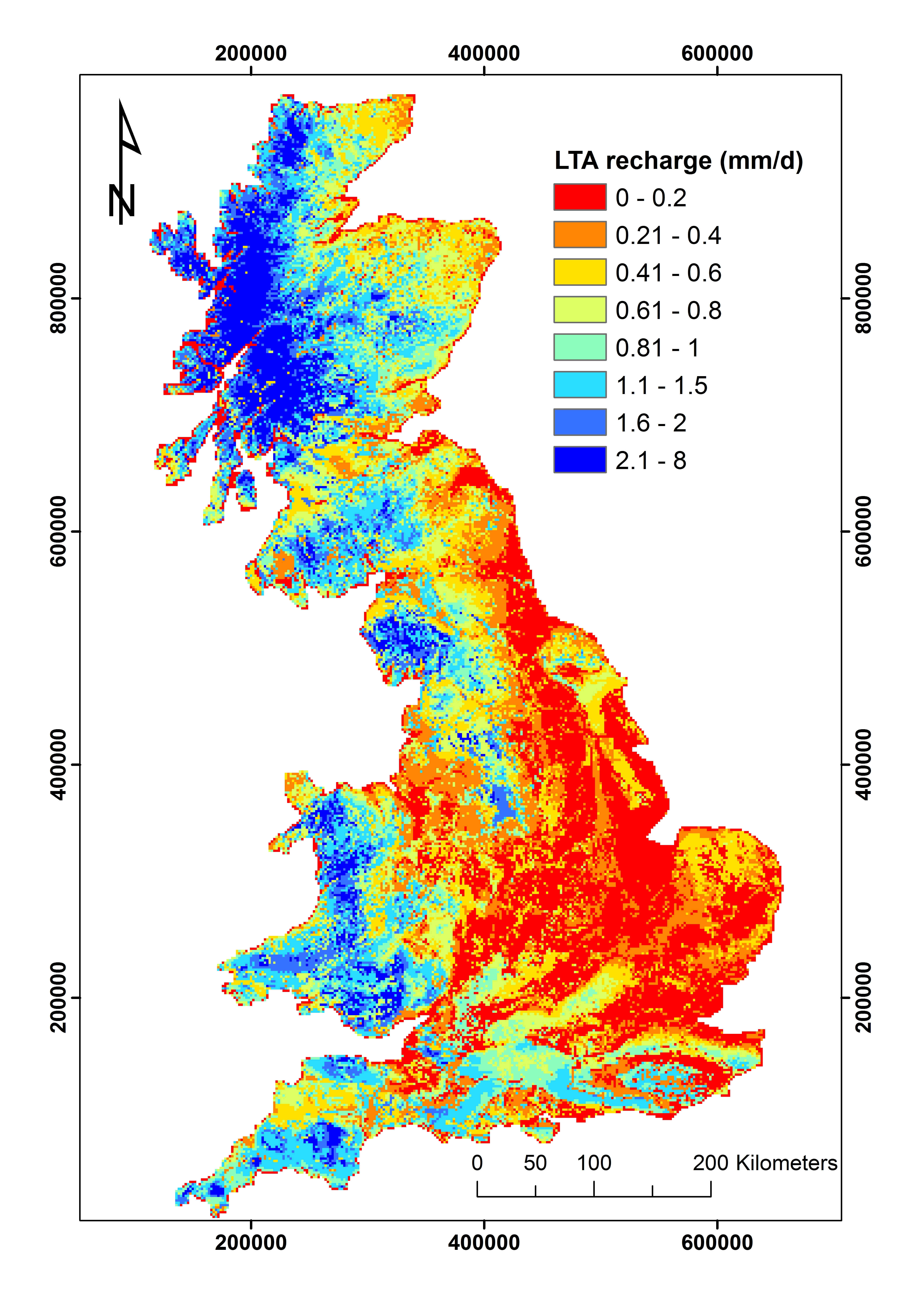
The GB-wide recharge model was built using BGS’ code ZOODRM. Potential recharge is calculated on a grid with 2 × 2 square kilometre cells over the area described by the following National Grid Reference: Bottom Left (40000, -10000) Top right (680000, 1010000). The model has been run for the period 1st January 1962 to 31st December 2010 and calibrated against the runoff component of river gauged flow. It calculates recharge on a daily basis and aggregates the recharge to a monthly value.
The calculation method used is the modified FAO as proposed by Griffiths et al. (2006). It uses the distribution of soil parameters and crop parameters obtained from the HOST soil data map, which includes 33 classes of soil types (Boorman et al., 1995), and the land cover map, Land Cover Map 2000 which includes 9 land use classes (Natural Environmental Research Council, 2000). The values of these parameters are obtained from the literature.
The model calculates potential recharge, which is the amount of water calculated to leave the bottom of the soil zone. It does not, therefore, take into account any modification of recharge resulting from the unsaturated zone and other, minor aquifers which may lie above the water table.
References
Boorman D B, Hollist J M and Lilly A. 1995. Hydrology of soil types: a hydrologically-based classification of the soils of the United Kingdom. Institute of Hydrology Report No. 126. Wallingford, UK
Griffiths, J, Keller, V, Morris, D and Young, A R. 2006. Continuous Estimation of River Flows (CERF) — Technical Report: Task 1.3: Model scheme for representing rainfall interception and soil moisture. Environment Agency R & D Project W6-101. Centre for Ecology and Hydrology, Wallingford, UK.
Natural Environment Research Council (NERC). 2000. Countryside Survey 2000 Module 7. Land Cover Map 2000 Final Report. Centre for Ecology and Hydrology, Wallingford, U.K
- BGS groundwater modelling publications
- Simple automatic time-stepping for improved simulation of groundwater hydrographs
- How to get your model results used : a guide to stakeholder engagement
- Grid refinement in Cartesian Coordinates for groundwater flow models using the Divergence Theorem and Taylor’s Series
- Numerical testing of conceptual models of groundwater flow: a case study using the Dumfries Basin aquifer


