Groundwater flooding FAQs
In recent years groundwater has been recognised as a significant source of flooding in the UK. Here are answers to questions you may have relating to this type of flooding:
Please note, the BGS is not able to advise on specific flooding events or queries on individual home buyer reports.
Flooding can occur from many sources including groundwater, surface water, runoff from intense rainfall, as well as cracked pipes.
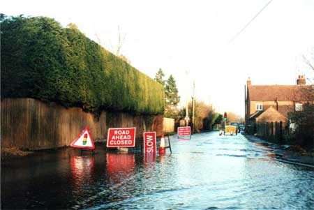
Groundwater flooding occurs when the water table in permeable rocks rises to enter basements/cellars or comes up above the ground surface. Groundwater flooding is not necessarily linked directly to a specific rainfall event and is generally of longer duration than other causes of flooding (possibly lasting for weeks or even months).
Groundwater levels are generally highest in early spring and lowest in early autumn. Therefore flooding that occurs in June to September is not normally caused by groundwater. Flooding that responds rapidly to rainfall events is also unlikely to be caused by high groundwater levels; exceptions do occur if the water table is normally very shallow and it has been very wet.
Information on the risk of surface water flooding is held by the Environment Agency (for England), Natural Resources Wales, the Scottish Environment Protection Agency or the Rivers Agency of Northern Ireland.
Pluvial flooding — flooding relating to rainfall — is caused by a combination of rainfall intensity and the local drainage conditions. The BGS does not hold any information on this.
Flooding might also be caused by leaking pipes. Sources of information on the distribution of pipes that could have become cracked or leak are: your water supply and/or water & sewerage company; and your local council.
If the water contains TCM (trichloromethane) it is likely to be caused by mains leakage, as this is a residual of the chlorination process. Your water supply company may offer to analyse the flood waters to see if it contains TCM.
If the flooding is related to rainfall events it could be caused by a fractured storm drainage pipe.
Please note, the BGS is not able to advise on specific flooding events or queries on individual home buyer reports.
Since the Flood & Water Management Act came into force in 2010 the Lead Local Flood Authority (LLFA) has had a duty to investigate to the extent it feels necessary or appropriate. An internet search should enable you to find out the LLFA for your area. The LLFA, e.g. a county council, may have delegated the duty to investigate flooding to local district councils.
The duty to investigate does not require the LLFA to tackle groundwater flooding but merely keep a record of the investigation. However, they may be able to advise on a course of action.
The measures that you can implement to stop groundwater flooding are limited and often not totally effective. These include the construction of additional drainage on your property or the installation of dewatering pumps in your basement.
Measures to reduce the impact of the flooding that occurs include the tanking of basements and adaptations within your house similar to those suggested by the environment regulators for flooding from overland flows, for example from the Environment Agency.
Please note, the BGS is not able to advise on specific flooding events.
New springs discharging at locations where there is no local knowledge of these occurring previously are most likely due to a leaking pipe or some other manmade cause. However, natural springs can flow temporarily due to periods of sustained rainfall in combination with abnormally high groundwater levels. Springs occur where the groundwater level rises above the ground surface or where there is a barrier to the flow of groundwater, either natural or artificial, in the underlying rock, causing water to discharge to the ground surface. If the spring does not normally flow then there is unlikely to be a drainage channel to direct the flow to an established water course. The water will find its own course potentially flooding property down-gradient.
Under Common Law, occupiers of land are under a general duty with regards to hazards occurring on their land to take reasonable steps to remove or reduce the impact on their neighbours. This would apply to the emergence of a natural spring, or a spring caused by leaking pipes, which then flood a neighbouring property. A breach of this duty could constitute a nuisance, which is actionable within the civil courts. In determining what amounts to reasonable steps to reduce or remove such hazards the courts will consider the costs of the steps required to alleviate the hazard and the financial means of the occupier.
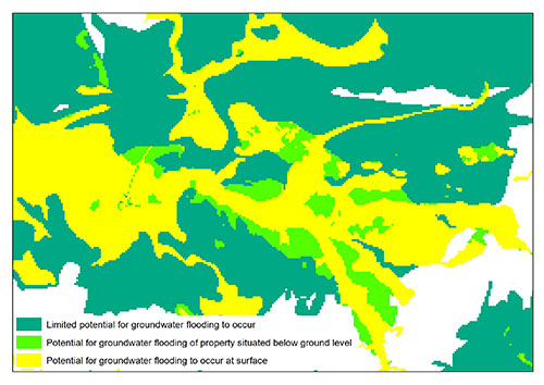
BGS has produced the first dataset for Great Britain that provides an assessment of the susceptibility to groundwater flooding. Based on geological and hydrogeological information, the digital data can be used to identify areas where geological conditions could enable groundwater flooding to occur and where groundwater may come close to or above the ground surface.
The method to derive the dataset involves initially identifying those areas with rocks that are sufficiently permeable to allow groundwater flooding to occur. Where the rock layer is made up of a range of rock material that may have different permeabilities, we take the worst case scenario and use the highest likely permeability.
Where the rocks are permeable we assess the potential for groundwater flooding on whether groundwater may be present at shallow depths and could rise to enter basements/cellars or under certain circumstances come above the ground surface.
This rock permeability is combined with a groundwater surface for periods when groundwater levels are high. This is an approximated surface based on:
- regional groundwater level contours
- point measurements of groundwater level
- river levels (making the assumption that the river is an expression of the water table at that location)
The groundwater level surface modelled with these data is then used to calculate a depth to groundwater in areas where the rocks are sufficiently permeable. This depth is then used to classify the susceptibility to groundwater flooding.
More about the BGS Susceptibility to groundwater flooding dataset.
The BGS has produced maps of the susceptibility to groundwater flooding for England, Wales and Scotland, which we proivde to companies that produce home buyer reports. However, the BGS is not the sole provider of groundwater flooding data, and you should check the details of the report to find out who supplied the data.
These maps are based on a model that takes into consideration the height of the land around a property but not the height of the property itself. The model is not at the individual property scale, so is not definitive and should be used as guidance only.
Susceptibility is not the same as risk. These maps show where there is the potential for groundwater flooding but do not give any indication of the probability that it will occur.
We classify our groundwater flooding susceptibility/potential into three categories, which may have been included in your home buyer's report. These categories and the actions that we suggest you might take are provided in this table:
Groundwater susceptibility |
Basis of susceptibility classification and advice on action to take |
|---|---|
A |
Potential for groundwater flooding to occur at surface: based on rock type and estimated groundwater level during periods of extended intense rainfall. You are advised to check that this has not been a problem in the past at this location and/or that measures are in place to sufficiently reduce the impact of the flooding. |
B |
Potential for groundwater flooding of property situated below ground level: based on rock type and estimated groundwater level during periods of extended intense rainfall. Where this may have an impact, you are advised to check that this has not been a problem in the past at this location and/or that measures are in place to sufficiently reduce the impact of the flooding. |
C |
Limited potential for groundwater flooding to occur: based on rock type and estimated groundwater level during periods of extended intense rainfall. |
Elsewhere |
Not considered to be prone to groundwater flooding: based on rock type. |
Please note, the BGS is not able to answer queries relating to individual home buyer reports.
If the advice, based on our groundwater flood susceptibility classification, is that you check there has not been a problem in the past at your property, we suggest you ask the current owners and neighbours, or undertake an internet search, to try to identify evidence of past flooding events that may indicate that groundwater flooding is an issue.
The age of the property may be a help in assessing the likely potential for, or impact of, flooding as older houses are more likely to have been designed with flood risk in mind.
Even if an area is prone to groundwater flooding, a property's construction (e.g. presence of a basement, level of the ground floor, construction of local drainage etc.) can determine whether or not this poses any problems to a householder.
Not necessarily. It is important to remember that if an area is susceptible to groundwater flooding it does not mean that groundwater flooding has ever occurred in the past, or will do so in the future, as the maps do not contain information on how often flooding is likely to occur (the probability or return period) or to what depth but just that the physical setting is such that it could occur.
The susceptibility maps are designed for planners, identifying areas where groundwater flooding might be an issue. The computer model we use to classify areas produces maps with a pixel size of 50 metres. Because of this coarse resolution it is possible that the actual susceptibility at your property may be different due to small-scale variations in rock and soil type and local landscape.
So, although information from the maps is often included in home buyer reports, it really should not be used in isolation as an indicator of groundwater flooding susceptibility and risk at individual properties. You may be able to find more specific information about the site you are interested in by viewing our geological maps or by searching our borehole records for information on water strikes and groundwater levels.
You should also be aware that home buyer reports often look within a relatively large radius from the property, sometimes over 100 metres, and report back the highest susceptibility that they find. Therefore, it may be that our maps give a lower susceptibility at your property than the report indicates.
Yes. Further details on the Susceptibility to Groundwater Flooding dataset can be obtained from BGS Digital Products or Susceptibility to Groundwater Flooding .
This includes information on the resolution, cost and format of the data licensed.
If you are a developer and only need to purchase a small area of the dataset it may be more cost effective to obtain the data from one of the value added resellers that the BGS supply.
Groundsure, Landmark and Argyll Environmental all resell our data in their reports.
F!ND resells the data in GIS format and as a view service.
Contact
Contact Enquiries for further information


