Groundwater and flooding in Forres
The British Geological Survey (BGS) has undertaken investigations to assess the groundwater aspects of flooding in the Forres area of Scotland.
Recommendations were made as a result of the study, relating to the design of drainage channels, the implications of further urban development and the efficacy of upstream flood impoundments, which were incorporated into the proposed alleviation scheme.
Protecting Forres from flood
Forres is situated in north-east Scotland on the Moray coast and has a population of approximately 9000. The town has a long history of flooding from the River Findhorn and the Burn of Mosset.
To help protect the town a series of flood alleviation schemes have been proposed and the Burn of Mosset scheme has already been constructed and is in operation.
The proposed River Findhorn scheme involves a series of embankments and river channel engineering to stop the westward movement of flood water from the River Findhorn through Forres, and a series of drains to remove storm water from the Pilmuir catchment.
The role of groundwater is critical to the operation and effectiveness of the flood alleviation scheme. Work was undertaken by BGS to assess the groundwater aspects of flooding and implications for the efficacy of the proposed alleviation scheme. The project was funded by Moray Council.
Groundwater investigations in Forres
BGS undertook detailed groundwater investigations which included hydrogeological surveys, aquifer property testing and groundwater monitoring.
This enabled a conceptual understanding of the groundwater flow system and its interaction with surface waters which was tested and improved through numerical modelling.
The investigations indicated that there is a dual aquifer system in the Pilmuir catchment, with a shallow superficial sands and gravel aquifer that is generally highly permeable, underlain by a deeper, less-permeable bedrock aquifer.
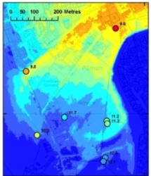
Groundwater flow, mostly within the top 8 m, is generally from south to north, following the topographic gradient. Groundwater discharges constantly through the existing storm drain system in Pilmuir.
Groundwater levels are shallow and approach ground surface in parts. The River Findhorn is well-connected to the aquifer system.
The role of groundwater in flooding
From the groundwater investigations it is possible to infer mechanisms for flooding in the Pilmuir area.
Very shallow groundwater gives rise to marshy areas, with some peat development and willow growth in the Pilmuir area. The water-logged soils reduce the ability of rain to infiltrate, leading to large areas of ponded water for parts of the year.
The increased urbanisation in the upper part of the catchment is likely to have increased run-off, and the use of soakaways will have raised groundwater levels in the lower part of the catchments. Groundwater also plays a role in the larger flood events.
Generally, the high infiltration capacity of the soil in the upper parts of the catchment means that run-off is limited, and the flood extent is reduced. However, this recharge can have a longer-term impact on groundwater levels, increasing the risk of ponding at other times of the year.
The constant groundwater discharge through the existing storm-water drain also reduces the capacity of the drain to discharge run-off during flood events.
Recommendations to reduce flood risk
The groundwater investigations enabled potential scheme designs to be assessed and optimised. Recommendations were made on the design of new drainage channels and embankments to ensure that groundwater levels were kept low while still allowing space in the drains to effectively discharge surface waters adequately during flood events.
The potential for further urban development to increase groundwater flood risk was also highlighted.
Key publication
MacDonald, A M, Hughes, A G, Vounaki, T, Graham, M T, Lilly, A, Mansour, M and Stephens, C A. 2008. Groundwater and the Forres (River Findhorn & Pilmuir) flood alleviation schemes. British Geological Survey Commissioned Report CR/08/023 (contact The Moray Council if you wish to view this report).
Contact
Contact Alan MacDonald for further information


