Karst features
Stream sinks
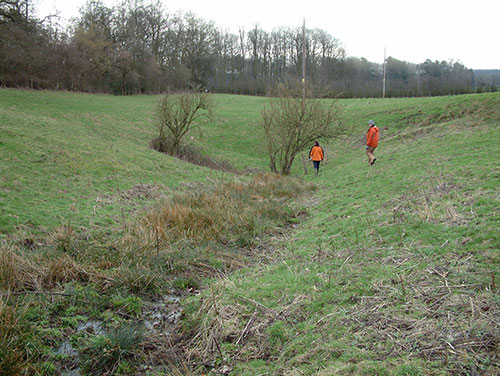
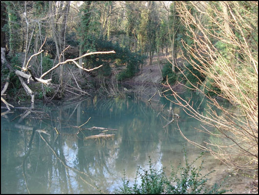
Stream sinks (also known as swallow holes) are points at which water sinks directly into the ground. In some cases they may be associated with a surface depression, and in others they may just be focused points within a stream bed where water disappears into the ground. They are distinguished from dolines by their hydrologically active nature, although many are ephemeral and do not flow constantly.
Karst stream sinks occur relatively frequently in the Chalk, the Jurassic limestone and the Permian limestone. Stream sinks are often associated with geological boundaries where there are lower-permeability deposits overlying the karstic rock. Surface run-off forms streams or rivers on the lower-permeability deposits, which then sink into the underlying karst, at or close to the geological boundary.
Chalk stream sinks have been most extensively mapped, and this has revealed that they can have very high densities along the boundary between the Chalk and the overlying Palaeogene clays and sands. For example, in the Pang and Lambourn catchments in Berkshire, more than 130 stream sinks have been mapped (Maurice et al., 2006). Whilst individually these Chalk stream sinks have relatively small flows, ranging from small seeps to streams with flows of several litres per second following rainfall, collectively they form an important contribution to recharge and provide a direct flow path into the aquifer.
Dolines
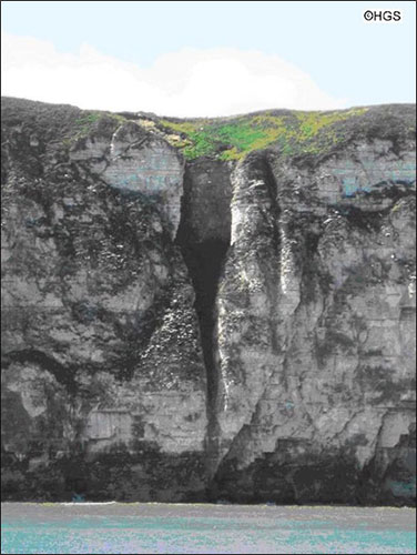
Dolines (also known as sinkholes) are surface depressions that are formed by solution processes and are not associated with a stream. They are formed by natural processes, unlike some surface depression that are sometimes called 'sinkholes' but are formed by collapse into artificial cavities. They are generally classified as solution dolines, collapse dolines or subsidence dolines. Dolines may be palaeokarst features that are not currently hydrologically active. However, they are genetically karstic and their presence implies that there is or has been a fully connected flow path between the doline and the aquifer discharge point, enabling transport of solute and/or sediment through the aquifer (Williams, 2004).
Dolines are present in the Chalk and the Jurassic and Permian limestone, where they are usually smaller than dolines in Carboniferous limestone. However, one of the most famous karst dolines in the UK is Culpeppers Dish in the Chalk in Dorset, which is 21 m deep and 86 m in diameter. Doline densities in Dorset can be more than 100/km2, which is comparable to those in the South Wales Carboniferous limestone (Sperling et al., 1977). In some areas it can be difficult to distinguish dolines from artificial pits that may have a similar shape.
Solution pipes
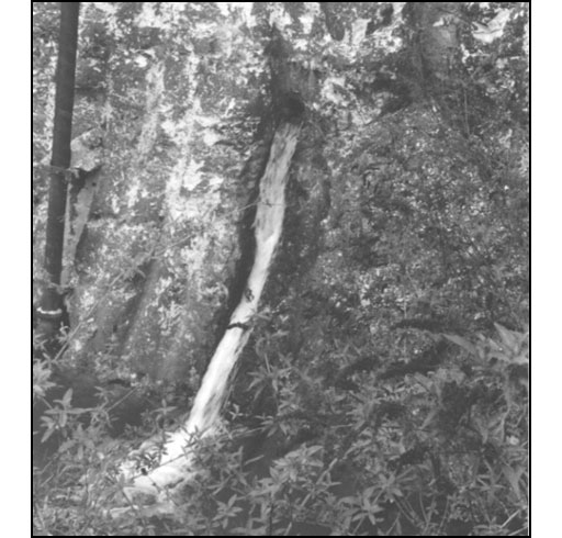
Solution pipes are subsurface solutional voids that are filled with sediment. They may occur with no surface expression, and they are often filled with low-permeability material and so do not provide a rapid pathway to the subsurface. They are frequently encountered in engineering works, especially in the Chalk (Edmonds, 2008), and are indicative that karst processes are occurring in the area.
Conduits observed in quarries or boreholes
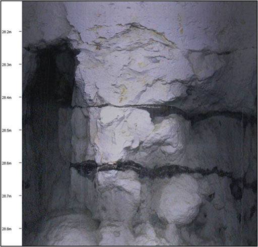
Small conduits from a few to tens of centimetres in diameter are revealed in quarries and on images of borehole walls. Although these are quite small in size, water can move rapidly through these conduits.
Large springs
In karst studies, high temporal resolution discharge and water-quality data are used to assess the nature of karst. A higher degree of karstification is associated with springs that have rapid responses to precipitation resulting in changes in discharge and chemistry over periods of hours or days (Shuster and White, 1971; White, 1988).
Large springs (more than 10 l/s, and especially those more than 100 l/s) in themselves are indicative of karst processes, as a connected network of solutional voids of sufficient size is required to sustain the discharge.
Tracer tests
Successful tracer tests demonstrate the location of rapid karstic groundwater flow paths. Testing in the Chalk and Jurassic limestone has demonstrated groundwater velocities of several kilometres per day over distances of several kilometres (e.g. Atkinson and Smith, 1974; Banks et al., 1995; Foley et al., 2012).
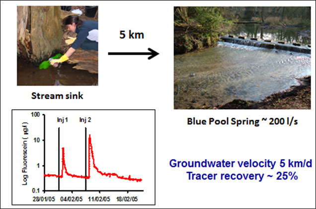
One example is a tracer test in Berkshire, which involved injecting only a few hundred millilitres of a sodium fluourescein dye solution into a stream sink (Maurice et al., 2006). The tracer arrived five kilometres away at the Blue Pool spring in just 24 hours, illustrating how vulnerable these aquifers can be to pollution.
Microbial contamination and turbidity
Karst aquifers are often characterised by high incidences of microbial pollutants, which often occur following recharge events. The presence of microbial contaminants in boreholes and springs is indicative of short residence-time groundwater, as some microbial contaminants only persist in aquifers for 1–2 weeks. Increased turbidity in springs and boreholes following rainfall can also be indicative of karst flow paths.
References
Chalk karst groundwater
Atkinson, T C, and Smith D I. 1974. Rapid groundwater flow in fissures in the Chalk: An example from South Hampshire. Quarterly Journal of Engineering Geology 7, 197–205.
Banks, D, Davies, C, and Davies, W. 1995. The Chalk as a karstic aquifer: evidence from a tracer test at Stanford Dingley, Berkshire, UK. Quarterly Journal of Engineering Geology 28, S31–S38.
Edmonds, C. 2008. Improved groundwater vulnerability mapping for the karstic Chalk aquifer of south east England. Engineering Geology 99 (95–108).
MacDonald, A M, Brewerton, L J, and Allen, D J. 1998 Evidence for rapid groundwater flow and karst-type behaviour in the Chalk of southern England. In: Robins, NS (ed.) Groundwater pollution, aquifer recharge and vulnerability. Geological Society of London, 95–106. (Geological Society Special Publications, 130).
Maurice, L D, Atkinson, T A, Barker, J A, Bloomfield, J P, Farrant, A R, and Williams, A T. 2006. Karstic behaviour of groundwater in the English Chalk. Journal of Hydrology 330 53–62. 10.1016/j.jhydrol.2006.04.012
Maurice, L D, Atkinson, T C, Williams, A T, Barker, J, and Farrant, A R. 2010. Catchment scale tracer testing from karstic features in a porous limestone. Journal of Hydrology. 389 (1–2) 31–4. 10.1016/j.jhydrol.2010.05.019
Maurice, L D, Atkinson, T C, Barker, J, Williams, A T, and Gallagher, A. 2012. The nature and distribution of flowing features in a weakly karstified porous limestone aquifer. Journal of Hydrology. 438–439, 3–15. 10.1016/j.jhydrol.2011.11.050
General karst groundwater
Foley, A, Cachandt, G, Franklin, J, Willmore, F, and Atkinson, T. 2012. Tracer tests and the structure of permeability in the Corallian limestone aquifer of northern England, UK. Hydrogeology Journal 20, 483–498.
Jourde, H, Lafare, A, Mazzilli, N, Belaud, G, Neppel, L, Dörfliger, N, and Cernesson, F. 2014. Flash flood mitigation as a positive consequence of anthropogenic forcing on the groundwater resource in a karst catchment. Environmental Earth Sciences, 71 (2). 573–583. 10.1007/s12665-013-2678-3
Banks, V J, and Jones, P F. 2012. Hydrogeological significance of secondary terrestrial carbonate deposition in karst environments. In: Kazemi, G A, (ed.) Hydrogeology : a global perspective. InTech, 43–78.
Farr, G, Lawrence, D, Whitbread, K, Jones, D A, and Roberts, K. 2015. The ‘Great Spring’: updating a source protection zone in a complex karst aquifer. [Poster] In: KG@B Conference International Conference on Groundwater in Karst, Birmingham, UK, 20–26 June 2015. (Unpublished)
Maurice, L, and Guilford, T. 2011. The hydrogeology of Ogof Draenen : new insights into a complex multi-catchment karst system from tracer testing. Cave and Karst Science, 38 (1). 23–30.
Shuster, E T, and White, W B. 1971. Seasonal fluctuations in the chemistry of limestone springs: a possible means for characterising carbonate aquifers. Journal of Hydrology 14, 19–128.
Worthington, S R H, and Ford, D C. 2009. Self-organised permeability in carbonate aquifers. Groundwater 47 (3), 326–336.
Karst geomorphology
Cooper, A H, Farrant, A R, and Price, S J. 2011. The use of karst geomorphology for planning, hazard avoidance and development in Great Britain. Geomorphology, 134 (1–2). 118-131. 10.1016/j.geomorph.2011.06.004
Dale, J, and Thomas, C. 2016. Caves of the North York Moors. Chapter 33 in Caves and Karst of the Yorkshire Dales (volume 2) edited by Waltham, A, and Lowe, D. 2.3 MB pdf
Farrant, A, and Cooper, A. 2008. Karst geohazards in the UK : the use of digital data for hazard management. Quarterly Journal of Engineering Geology and Hydrogeology, 41 (3). 339–356. 10.1144/1470-9236/07-201
Gallois, R.W. 2005. The development and origin of karst in the Upper Greensand Formation (Cretaceous) of south-west England. Geoscience in south-west England — Proceedings of the Ussher Society, 11 (1). 30–36.
Sperling, C H B, Goudie, A S, Stoddart, D R, and Poole, G G. 1977. Dolines of the Dorset chalklands and other areas in southern Britain. Transactions of the Institute of British Geographers 2, 205–223.
White, W B. 1988. Geomorphology and hydrology of Karst Terrains. New York and Oxford, Oxford University Press. 464 pp.
Williams, P. 2004. Dolines. In Encyclopaedia of caves and karst science. Edited by Gunn, J. 304–310.
Contact
Contact Louise Maurice for further information.


