3D Modelling
- Regional Modelling
- Urban Modelling
Regional Modelling
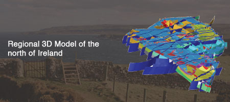
The regional model shows large geological structures in the north of Ireland.
The Regional Scale 3D Model is constructed around a framework of 15 km deep geological cross-sections and a fault network covering Northern Ireland and the northern half of Ireland. The sections capture published and unpublished geological knowledge, e.g. from survey and academic mapping and publications, deep boreholes and regional geophysical surveys including Tellus. When combined with outcrop/subcrop maps for each of the basement blocks and geological time periods, the model is able to calculate bases of units from which volumes will eventually be derived. The model is intended as a regional scale, deep bedrock, context setter for government and major geoscience organisations, academia and industry to aid decision making and to guide future research. A further use for the model is as an educational resource for academia and industry.
Urban Modelling
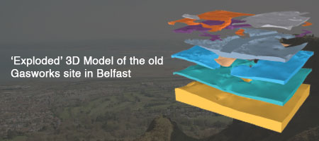
Urban models focus on the superficial deposits such as the Belfast Sleech shown in grey above.
Three urban models have been developed.
- Belfast Urban Model
- Londonderry Urban Model
- Belfast Old Gasworks Model
In contrast to the Regional Model, the urban models are constructed largely from borehole data and focus on shallow superficial deposits.
Model Development and Delivery
The regional and urban models are developed in GSI3D. More information about GSI3D.
The GSNI 3D models are delivered to end users though the Lithoframe viewer. This 3D viewer allows the construction of synthetic cross-sections and boreholes and 'explosion' of the model in 3D space.