Permeability of rocks
What is the permeability of rocks?

The term permeability refers to whether and how water can flow through a rock. Permeability data is often used in studies of groundwater and in particular during investigations of pollution or aquifer contamination. The BGS has prepared permeability information based on the BGS Geology 50k. This note describes what permeability information is available and how the permeability information should be used. The data is typically supplied in GIS format.
How is the data modelled?
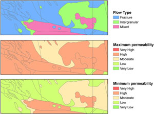
BGS Geology holds information for four layers representing four different types of deposits: artificial, mass movement, drift, and solid. At any location, solid rocks will always be present, but the other three may not be. All geological (lithostratigraphical) units for all four layers on the BGS Geology 50k have been assigned three permeability indices. Pebbly sandstone Bromsgrove Sandstone Formation is an example of a lithostratigraphical unit.
The permeability indices are based on geological considerations and are as follows:
- the predominant flow mechanism, either intergranular flow, fracture flow, or a mixture of intergranular and fracture flow
- a maximum permeability index
- a minimum permeability index
The permeability indices indicate the range of permeability likely to be encountered for each BGS Geology unit. The maximum and minimum permeability indices are divided into five classes: very high, high, moderate, low, and very low permeability.
What does the data show?

The permeability indices are based on estimates of vertical effective permeability and do not take into account horizontal rock variability. The indices also do not consider the thickness of either the unsaturated or saturated part of the rock unit.
Therefore to assess the overall vulnerability of groundwater to pollution from the ground surface at a particular location, the following additional information would be required:
- the physical and chemical characteristics of the soil
- the thickness of, and depth to water in, the different geological layers present
The permeability indices are suitable for use in regional planning exercises. Site investigations will be necessary for individual site-specific activities.
More information about the permeability data, including how to access it, can be found in our data product section or by contacting digitaldata@bgs.ac.uk.


